IMAGES TAKEN NEAR TO
Woodville Road, CINDERFORD, GL14 2AY
Introduction
This page details the photographs taken nearby to Woodville Road, GL14 2AY by members of the Geograph project.
The Geograph project started in 2005 with the aim of publishing, organising and preserving representative images for every square kilometre of Great Britain, Ireland and the Isle of Man.

There are currently over 7.5m images from over14,400 individuals and you can help contribute to the project by visiting https://www.geograph.org.uk
Image Map
Images are licensed for reuse under creativecommons.org/licenses/by-sa/2.0
Notes
- Clicking on the map will re-center to the selected point.
- The higher the marker number, the further away the image location is from the centre of the postcode.
Image Listing (76 Images Found)
Images are licensed for reuse under creativecommons.org/licenses/by-sa/2.0
Image
Details
Distance
1
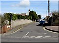
Woodville Road, Cinderford
From Belle Vue Road.
Image: © Jaggery
Taken: 12 Apr 2015
0.04 miles
2
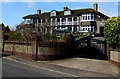
Penrhos and Tyndale, Cinderford
Distinctive semi-detached houses set back from Littledean Hill Road
at 245 metres (800ft) above sea level near the eastern edge of Cinderford.
Image: © Jaggery
Taken: 12 Apr 2015
0.06 miles
3
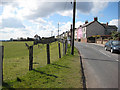
Cottages on Littledean Hill Road
With superb views over the Severn.
Image: © Pauline E
Taken: 27 Mar 2008
0.07 miles
5
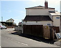
Flaxley Street electricity substation, Cinderford
The Central Networks electricity substation is in a wooden enclosure on the corner of Flaxley Street and Belle Vue Road. An Environmental Awareness label shows that the equipment is registered as PCB contaminated (less than 0.05% by weight). PCB = polychlorinated biphenyl.
Image: © Jaggery
Taken: 12 Apr 2015
0.09 miles
6
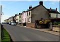
Littledean Hill Road houses, Cinderford
At the eastern edge of town.
Image: © Jaggery
Taken: 12 Apr 2015
0.09 miles
7
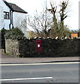
Wall postbox, Belle Vue Road, Cinderford
In April 2015, the King George VI postbox http://www.geograph.org.uk/photo/4428370 needs a repaint.
Image: © Jaggery
Taken: 12 Apr 2015
0.09 miles
8
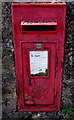
King George VI postbox in a Belle Vue Road wall, Cinderford
In need of a repaint in April 2015. Located here. http://www.geograph.org.uk/photo/4428374
Image: © Jaggery
Taken: 12 Apr 2015
0.09 miles
9
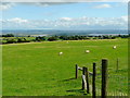
Double View 1
The crest of Littledean Hill provides a spectacular view east over the Arlingham loop of the Severn and on to the Cotswolds.
The view west from the houses on Littledean Hill Road would be over Cinderford to the Forest of Dean.
Image: © Jonathan Billinger
Taken: 25 Aug 2009
0.09 miles
10
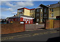
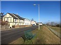
St Anthony's School & Nursery, Cinderford
Viewed across Flaxley Street. Though the school has strong links with the adjacent Our Lady
of Victories Catholic Church, http://www.geograph.org.uk/photo/4425705 the school welcomes children of any faith, or none.
Image: © Jaggery
Taken: 12 Apr 2015
0.09 miles