IMAGES TAKEN NEAR TO
WESTBURY-ON-SEVERN, GL14 1PE
Introduction
This page details the photographs taken nearby to GL14 1PE by members of the Geograph project.
The Geograph project started in 2005 with the aim of publishing, organising and preserving representative images for every square kilometre of Great Britain, Ireland and the Isle of Man.

There are currently over 7.5m images from over14,400 individuals and you can help contribute to the project by visiting https://www.geograph.org.uk
Image Map (Loading...)


Getting Data...Please wait
Leaflet Map data © OpenStreetMap
Images are licensed for reuse under creativecommons.org/licenses/by-sa/2.0
Notes
- Clicking on the map will re-center to the selected point.
- The higher the marker number, the further away the image location is from the centre of the postcode.
Image Listing (266 Images Found)
Images are licensed for reuse under creativecommons.org/licenses/by-sa/2.0
Image
Details
Distance
1
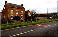
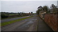
Arden's Farm, Westbury-on-Severn
On the north side of the A48 at the eastern edge of the village.
Image: © Jaggery
Taken: 25 Jan 2015
0.03 miles
2
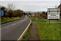
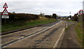
Eastern boundary of Westbury-on-Severn
The A48 reaches Westbury-on-Severn, a village in the Forest of Dean district of Gloucestershire.
The blue sign on the left shows that a parking area is 150 yards ahead.
Image: © Jaggery
Taken: 25 Jan 2015
0.03 miles
3
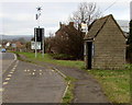
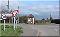
Bus shelter and a green sign in Westbury-on-Severn
The sign alongside the A48 is green in the sense that its display
is powered by a combination of wind energy and solar energy.
Image: © Jaggery
Taken: 25 Jan 2015
0.04 miles
4
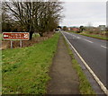
Westbury Court Garden left ahead, Westbury-on-Severn
The depiction of oak leaves on the sign alongside the A48 indicates a National Trust site.
Image: © Jaggery
Taken: 25 Jan 2015
0.04 miles
5

Drainage channel, Westbury-on-Severn
On the south side of the A48, this unnamed channel (or perhaps brook) empties into the River Severn
near The Strand, about 800 metres ahead. That's the straight line distance.
The meandering course of this channel/brook is about 1.2km to the Severn.
Image: © Jaggery
Taken: 25 Jan 2015
0.06 miles
6
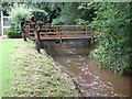
Footbridge over Westbury Brook
In the grounds of Westbury Court Garden, links the formal garden with a more recently acquired strip on the other side. Flood defences have been improved to prevent a repeat of flooding from the River Severn.
Image: © Liz Stone
Taken: 9 Jul 2012
0.06 miles
7
A48 near Westbury on Severn
Showing the very useful layby for parking to visit the water gardens and the railings for taking picture through.
Image: © David Robinson
Taken: 24 Dec 2008
0.07 miles
8
Imperial and metric signs, Westbury-on-Severn
Three of the four signs alongside the A48 use imperial measurements (15' 3", 1 mile and 50 (mph)).
The smaller size of the metric headroom sign suggests it was added as an afterthought.
Image: © Jaggery
Taken: 25 Jan 2015
0.07 miles
9
Telephone Exchange, Wintles Hill
Looking North across the A48.
Image: © Pauline E
Taken: 23 Mar 2009
0.07 miles
10
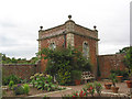
The Summerhouse, Westbury Court Garden
A Dutch style water garden rescued by the National Trust in 1967 and beautifully restored. It is now restored to its 1720 appearance with plants authentic to the period and style of the garden.
Image: © Pauline E
Taken: 31 Aug 2007
0.08 miles