IMAGES TAKEN NEAR TO
Awre, NEWNHAM, GL14 1EL
Introduction
This page details the photographs taken nearby to GL14 1EL by members of the Geograph project.
The Geograph project started in 2005 with the aim of publishing, organising and preserving representative images for every square kilometre of Great Britain, Ireland and the Isle of Man.

There are currently over 7.5m images from over14,400 individuals and you can help contribute to the project by visiting https://www.geograph.org.uk
Image Map (Loading...)


Getting Data...Please wait
Leaflet Map data © OpenStreetMap
Images are licensed for reuse under creativecommons.org/licenses/by-sa/2.0
Notes
- Clicking on the map will re-center to the selected point.
- The higher the marker number, the further away the image location is from the centre of the postcode.
Image Listing (7 Images Found)
Images are licensed for reuse under creativecommons.org/licenses/by-sa/2.0
Image
Details
Distance
1
Phone box outside the Village Hall in Awre
Image: © Sarah Charlesworth
Taken: 9 Aug 2010
0.10 miles
2
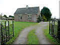
Awre village hall
Complete with Silver Jubilee gates from 1977.
Image: © Jonathan Billinger
Taken: 31 Dec 2009
0.11 miles
3
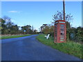
Telephone box and the road to Northington, Awre
Image: © Ruth Sharville
Taken: 25 Nov 2022
0.11 miles
4
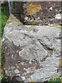
Rivet bench mark on Awre village hall
This Ordnance Survey rivet bench mark is on the south west corner of Awre village hall. See also Image
Image: © John S Turner
Taken: 8 Jun 2019
0.12 miles
5
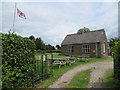
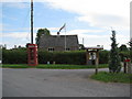
Awre village hall
Awre village hall flying the Union Flag on the Queen's official birthday, the 8th June 2019. The gates represent the Queen's Silver Jubilee, with the 1952 gates on the left, and the 1977 gates out of sight on the right. There is an Ordnance Survey rivet bench mark on the corner of the hall near the drainpipe: Image
Image: © John S Turner
Taken: 8 Jun 2019
0.12 miles
6
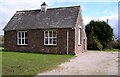
Village Hall, Awre
Had a pleasant pair of Gates commemorating the Queen's Silver Jubilee in 1977.
Image: © Stuart Wilding
Taken: 29 Mar 2006
0.15 miles