IMAGES TAKEN NEAR TO
Awre, NEWNHAM, GL14 1EG
Introduction
This page details the photographs taken nearby to GL14 1EG by members of the Geograph project.
The Geograph project started in 2005 with the aim of publishing, organising and preserving representative images for every square kilometre of Great Britain, Ireland and the Isle of Man.

There are currently over 7.5m images from over14,400 individuals and you can help contribute to the project by visiting https://www.geograph.org.uk
Image Map (Loading...)


Getting Data...Please wait
Leaflet Map data © OpenStreetMap
Images are licensed for reuse under creativecommons.org/licenses/by-sa/2.0
Notes
- Clicking on the map will re-center to the selected point.
- The higher the marker number, the further away the image location is from the centre of the postcode.
Image Listing (5 Images Found)
Images are licensed for reuse under creativecommons.org/licenses/by-sa/2.0
Image
Details
Distance
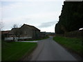
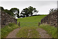
2
Box Farm
Situated in the very corner of the grid.
Image: © Stuart Wilding
Taken: 29 Mar 2006
0.04 miles
4
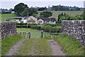
Box Farm
Box farm as seen from the railway bridge. To see the view the other way Image
Image: © Stuart Wilding
Taken: 31 Aug 2009
0.14 miles
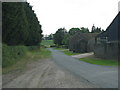
5
View of the bridge and beyond
View of the railway bridge near Box Farm. To see the view the other way Image
Image: © Stuart Wilding
Taken: 31 Aug 2009
0.24 miles