IMAGES TAKEN NEAR TO
Etheridge Place, GLOUCESTER, GL1 3QU
Introduction
This page details the photographs taken nearby to Etheridge Place, GL1 3QU by members of the Geograph project.
The Geograph project started in 2005 with the aim of publishing, organising and preserving representative images for every square kilometre of Great Britain, Ireland and the Isle of Man.

There are currently over 7.5m images from over14,400 individuals and you can help contribute to the project by visiting https://www.geograph.org.uk
Image Map
Images are licensed for reuse under creativecommons.org/licenses/by-sa/2.0
Notes
- Clicking on the map will re-center to the selected point.
- The higher the marker number, the further away the image location is from the centre of the postcode.
Image Listing (51 Images Found)
Images are licensed for reuse under creativecommons.org/licenses/by-sa/2.0
Image
Details
Distance
2
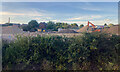
Waste recycling site, Gloucester
Two companies – Allstone and Speedy Skips – appear to occupy this site off Myers Road north of the railway. Mixed waste is brought in skips; loose bulky materials are retrieved and stockpiled for sale.
Image: © Robin Stott
Taken: 14 Jul 2022
0.06 miles
4

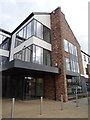
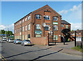
Aspen Centre
Aspen Centre, Medical centre on Horton Road in Gloucester.
Image: © Philip Halling
Taken: 13 Mar 2019
0.12 miles
5
![Gloucester buildings [16]](https://s3.geograph.org.uk/geophotos/06/58/07/6580735_1dc6ed7f_120x120.jpg)
Gloucester buildings [16]
A new First County Lunatic Asylum Chapel (later Horton Road Hospital Chapel) was built in Horton Road in 1873. The chapel remained in use until the early 1980's when it was converted into offices. Now part of the Chapel House Care Centre.
The cathedral city and county town of Gloucestershire, Gloucester lies on the River Severn and is linked via the Gloucester and Sharpness Canal to the river’s estuary. Founded by the Romans in AD 97, the city gained its first charter in 1155. In the Middle Ages there were a large number of monastic establishments including St Peter's Abbey founded in 679 - later Gloucester Cathedral. Until the construction of the Severn Bridge in 1966, Gloucester was the lowest road bridging point on the River Severn. The city has a long association with the aerospace business, including the Gloster Aircraft Company.
Image: © Michael Dibb
Taken: 1 Jun 2020
0.12 miles
6
Aspen Centre
Aspen Centre, a medical centre on Horton Road in Gloucester.
Image: © Philip Halling
Taken: 13 Mar 2019
0.12 miles
7
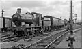
Local train from Cheltenham St James' entering Gloucester at Tramway Junction
View eastward, towards Cheltenham, also Birmingham and the North on both the ex-GW and ex-Midland routes (shared to Cheltenham Lansdown Junction); to the right is curving the ex-GW loop to Gloucester South Junction, Swindon, Bristol etc.
Image: © Ben Brooksbank
Taken: 16 Jun 1962
0.14 miles
8
Former factory, Horton Road, Gloucester
Possibly a former pin factory of 1897.
Now home to the Gloucester and District Irish Club.
Image: © Stephen Richards
Taken: 18 May 2015
0.14 miles
9
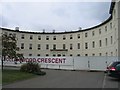
Collingwood Crescent
Originally part of the Gloucester Hospital this has now been sold off to developers and is being converted into flats.
Image: © David Stowell
Taken: 18 Sep 2005
0.14 miles
10
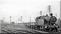
Down freight at Gloucester Tramway Junction, approaching from the Cheltenham lines
View eastwards, towards Cheltenham, Birmingham etc. (left) and the loop to Gloucester South Junction, Swindon and Bristol etc. (right): the Class H freight is on the southbound Slow line and crossing the Loop. The locomotive is Collett '5205' class 2-8-0T No. 5230 (built 6/24, withdrawn 7/64). (For route details, see other scenes at this location).
Image: © Ben Brooksbank
Taken: 26 Oct 1959
0.15 miles