IMAGES TAKEN NEAR TO
London Road, GLOUCESTER, GL1 3QE
Introduction
This page details the photographs taken nearby to London Road, GL1 3QE by members of the Geograph project.
The Geograph project started in 2005 with the aim of publishing, organising and preserving representative images for every square kilometre of Great Britain, Ireland and the Isle of Man.

There are currently over 7.5m images from over14,400 individuals and you can help contribute to the project by visiting https://www.geograph.org.uk
Image Map
Images are licensed for reuse under creativecommons.org/licenses/by-sa/2.0
Notes
- Clicking on the map will re-center to the selected point.
- The higher the marker number, the further away the image location is from the centre of the postcode.
Image Listing (174 Images Found)
Images are licensed for reuse under creativecommons.org/licenses/by-sa/2.0
Image
Details
Distance
1
![Gloucester houses [10]](https://s0.geograph.org.uk/geophotos/06/57/94/6579432_c34f008d_120x120.jpg)
Gloucester houses [10]
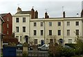
Number 118 London Road is at the end of Hillfield Parade (see Image and Image). Built circa 1827 in stoccoed brick with some late 19th century alterations. Listed, grade II, with details at: https://historicengland.org.uk/listing/the-list/list-entry/1245741
The cathedral city and county town of Gloucestershire, Gloucester lies on the River Severn and is linked via the Gloucester and Sharpness Canal to the river’s estuary. Founded by the Romans in AD 97, the city gained its first charter in 1155. In the Middle Ages there were a large number of monastic establishments including St Peter's Abbey founded in 679 - later Gloucester Cathedral. Until the construction of the Severn Bridge in 1966, Gloucester was the lowest road bridging point on the River Severn. The city has a long association with the aerospace business, including the Gloster Aircraft Company.
Image: © Michael Dibb
Taken: 1 Jun 2020
0.02 miles
2
Hillfield Parade, London Road ? 1
Built c.1827, Listed Grade II. This is the eastern section; the left hand house (no.118) is now Listed separately from the rest of the terrace.
Image: © Alan Murray-Rust
Taken: 16 Mar 2019
0.03 miles
3
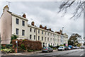
100 - 118 London Road
Stuccoed terrace on London Road, marked on old maps as Hillfield Parade, dating from around 1827. Grade II listed: for the nearest building, no 118, see www.historicengland.org.uk/listing/the-list/list-entry/1245741 - for the far building, nos 100 and 102, see www.historicengland.org.uk/listing/the-list/list-entry/1245737 - and for the terrace in between, nos 104 - 116, see www.historicengland.org.uk/listing/the-list/list-entry/1245739.
Image: © Ian Capper
Taken: 16 Mar 2019
0.03 miles
4
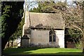
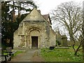
Remains of the Chapel of St Mary Magdalen
All that remains of the Chapel of St Mary Magdalen is the chancel. The chapel was built in the 12th century in a Norman and style and served the nearby St Mary Magdalen's Hospital which was probably founded for lepers. The nave of the chapel was demolished in 1861, while the hospital buildings were demolished soon afterwards.
Image: © Philip Halling
Taken: 1 Feb 2014
0.03 miles
5
Remains of the Chapel of St Mary Magdalen
All that remains of the Chapel of St Mary Magdalen is the chancel. The chapel was built in the 12th century in a Norman and style and served the nearby St Mary Magdalen's Hospital which was probably founded for lepers. The nave of the chapel was demolished in 1861, while the hospital buildings were demolished soon afterwards.
Image: © Philip Halling
Taken: 1 Feb 2014
0.03 miles
6
Norman arch
Norman arch to the chancel of the former chapel of St Mary Magdalen.
Image: © Philip Halling
Taken: 1 Feb 2014
0.03 miles
7

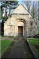
The Chapel of St Mary Magdalen
The chapel was built in the Romanesque style in the first part of the 12th century to serve the inmates of the hospital of St Mary Magdalen that stood some forty metres to the south-west. All that remains of the original chapel is the chancel; the rest of the chapel was taken down in 1861 due to its dangerous structural condition. More information can be found here http://www.britishlistedbuildings.co.uk/en-472311-chapel-of-st-mary-magdalene-remains-of-c#.VjehClbmtck
Image: © Ralph Tucker
Taken: 1 Nov 2015
0.03 miles
8
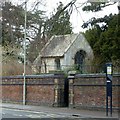
Chapel of St Mary Magdalene
The remains of the chapel attached to the leper hospital of St Mary Magdalene, comprising just the chancel. Essentially of the Norman period, the windows visible in this view being inserted in the 13th century. Listed Grade II*.
Image: © Alan Murray-Rust
Taken: 16 Mar 2019
0.03 miles
9
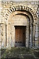
Chapel of St Mary Magdalene
The west front, displaying what was formerly the chancel arch, 12th century Norman. The doorway was the original south door from the nave, moved when the latter was demolished in 1861. The chapel formed part of the leper hospital of St Mary Magdalene. Listed Grade II*.
Image: © Alan Murray-Rust
Taken: 16 Mar 2019
0.03 miles
10
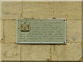
Chapel of St Mary Magdalene
Plaque installed by Gloucester City Council to their standard design.
Image: © Alan Murray-Rust
Taken: 16 Mar 2019
0.03 miles