IMAGES TAKEN NEAR TO
Great Western Road, GLOUCESTER, GL1 3PJ
Introduction
This page details the photographs taken nearby to Great Western Road, GL1 3PJ by members of the Geograph project.
The Geograph project started in 2005 with the aim of publishing, organising and preserving representative images for every square kilometre of Great Britain, Ireland and the Isle of Man.

There are currently over 7.5m images from over14,400 individuals and you can help contribute to the project by visiting https://www.geograph.org.uk
Image Map
Images are licensed for reuse under creativecommons.org/licenses/by-sa/2.0
Notes
- Clicking on the map will re-center to the selected point.
- The higher the marker number, the further away the image location is from the centre of the postcode.
Image Listing (178 Images Found)
Images are licensed for reuse under creativecommons.org/licenses/by-sa/2.0
Image
Details
Distance
1
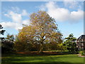
Gloucester: Plane Tree
This plane tree is in the garden situated behind the Wotton House, Redcliffe College in Wotton, Gloucester.
Image: © Alby
Taken: 4 Nov 2004
0.08 miles
2
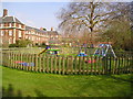
Gloucester: Playground behind the Wotton House
Playground situated in the garden behind the Wotton House, Redcliffe College.
Image: © Alby
Taken: 31 Mar 2004
0.08 miles
3
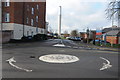
Mayhill Way
Mayhill Way off Horton Road gives access to the Gloucestershire Royal Hospital. The tall the chimney is a prominent feature on the Gloucester skyline.
Image: © Philip Halling
Taken: 1 Feb 2014
0.08 miles
4
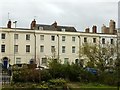
Hillfield Parade, London Road ? 2
Built c.1827, Listed Grade II. The central section is Listed separately from the houses at either end.
Image: © Alan Murray-Rust
Taken: 16 Mar 2019
0.10 miles
5
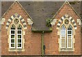
St Margaret's Almshouses ? detail
Detail of the London Road facade with Gothic windows and polychrome brickwork.
Built 1860-1 by Fulljames and Waller for the Gloucester Municipal Charity Trustees to house the United Hospitals formed after the amalgamation of the St Margaret and St Mary Magdelen and St Kyneburgh Hospitals in 1861. Listed Grade II.
Image: © Alan Murray-Rust
Taken: 16 Mar 2019
0.10 miles
6
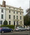
Hillfield Parade, nos.100/102 London Road
Built c.1827, Listed Grade II separately from the rest of the terrace.
Image: © Alan Murray-Rust
Taken: 16 Mar 2019
0.10 miles
7
![Gloucester buildings [8]](https://s3.geograph.org.uk/geophotos/06/57/94/6579419_5e01b130_120x120.jpg)
Gloucester buildings [8]
This pair of terrace houses, numbers 100 and 102 London Road, are at the end of Hillfield Parade (see Image and Image). Built circa 1827 in stuccoed brick. Number 100, Century House, is the head office of the Gloucester Charities Trust and number 102 has been converted into flats. Listed, grade II, with details at: https://historicengland.org.uk/listing/the-list/list-entry/1245737
The cathedral city and county town of Gloucestershire, Gloucester lies on the River Severn and is linked via the Gloucester and Sharpness Canal to the river’s estuary. Founded by the Romans in AD 97, the city gained its first charter in 1155. In the Middle Ages there were a large number of monastic establishments including St Peter's Abbey founded in 679 - later Gloucester Cathedral. Until the construction of the Severn Bridge in 1966, Gloucester was the lowest road bridging point on the River Severn. The city has a long association with the aerospace business, including the Gloster Aircraft Company.
Image: © Michael Dibb
Taken: 1 Jun 2020
0.10 miles
8
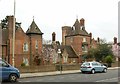
St Margaret's Almshouses
Built 1860-1 by Fulljames and Waller for the Gloucester Municipal Charity Trustees to house the United Hospitals formed after the amalgamation of the St Margaret and St Mary Magdelen and St Kyneburgh Hospitals in 1861. Listed Grade II.
Image: © Alan Murray-Rust
Taken: 16 Mar 2019
0.11 miles
9
![Gloucester buildings [7]](https://s2.geograph.org.uk/geophotos/06/57/86/6578634_c6c92bfd_120x120.jpg)
Gloucester buildings [7]
These almshouses were built in brick in 1861 on the site of the Leper Hospital of St Margaret and St Sepulchre (founded prior to 1163). There are 39 flats on the site. The style is Picturesque Domestic Gothic. The United Hospitals formed after the amalgamation of the St Margaret and St Mary Magdalen and St Kyneburgh Hospitals in 1861. Listed, grade II, with details at: https://historicengland.org.uk/listing/the-list/list-entry/1245724
The cathedral city and county town of Gloucestershire, Gloucester lies on the River Severn and is linked via the Gloucester and Sharpness Canal to the river’s estuary. Founded by the Romans in AD 97, the city gained its first charter in 1155. In the Middle Ages there were a large number of monastic establishments including St Peter's Abbey founded in 679 - later Gloucester Cathedral. Until the construction of the Severn Bridge in 1966, Gloucester was the lowest road bridging point on the River Severn. The city has a long association with the aerospace business, including the Gloster Aircraft Company.
Image: © Michael Dibb
Taken: 1 Jun 2020
0.11 miles
10
Almshouses, London Road, Gloucester
"One of the most picturesque works of F.S. Waller (Fulljames & Waller)". Built 1860-62. Grade II listed.
Formerly the United Almshouses, now St Margaret's.
See also Image] and Image
Image: © Stephen Richards
Taken: 18 May 2015
0.11 miles