IMAGES TAKEN NEAR TO
Pillowell Drive, GLOUCESTER, GL1 3LZ
Introduction
This page details the photographs taken nearby to Pillowell Drive, GL1 3LZ by members of the Geograph project.
The Geograph project started in 2005 with the aim of publishing, organising and preserving representative images for every square kilometre of Great Britain, Ireland and the Isle of Man.

There are currently over 7.5m images from over14,400 individuals and you can help contribute to the project by visiting https://www.geograph.org.uk
Image Map
Images are licensed for reuse under creativecommons.org/licenses/by-sa/2.0
Notes
- Clicking on the map will re-center to the selected point.
- The higher the marker number, the further away the image location is from the centre of the postcode.
Image Listing (154 Images Found)
Images are licensed for reuse under creativecommons.org/licenses/by-sa/2.0
Image
Details
Distance
1
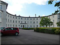
Former asylum, Horton Road, Gloucester
Former "hospital for the insane"/County Lunatic Asylum in 1814-23. William Stark's original design was altered in execution by John Wheeler, County Surveyor; he was superseded by his successor, John Collingwood. Among other innovations, it features the "very rare use of cast-iron tiles for roofing". Grade II listed.
Now flats.
Image: © Stephen Richards
Taken: 18 May 2015
0.04 miles
2
![Gloucester buildings [14]](https://s3.geograph.org.uk/geophotos/06/58/06/6580683_7dc0539a_120x120.jpg)
Gloucester buildings [14]
This is the main block of the Horton Road Hospital which opened in 1823 as the First Gloucestershire County Asylum. There were many later 19th century alterations and additions, principally wings and blocks. The hospital closed in 1988 and was converted to housing in 2005. Described by English Heritage as 'An outstanding early 19th century hospital complex, particularly notable for its advanced plan form, constructional techniques and fine neo-classical facade.' Listed, grade II*, with details at: https://historicengland.org.uk/listing/the-list/list-entry/1271680
The cathedral city and county town of Gloucestershire, Gloucester lies on the River Severn and is linked via the Gloucester and Sharpness Canal to the river’s estuary. Founded by the Romans in AD 97, the city gained its first charter in 1155. In the Middle Ages there were a large number of monastic establishments including St Peter's Abbey founded in 679 - later Gloucester Cathedral. Until the construction of the Severn Bridge in 1966, Gloucester was the lowest road bridging point on the River Severn. The city has a long association with the aerospace business, including the Gloster Aircraft Company.
Image: © Michael Dibb
Taken: 1 Jun 2020
0.05 miles
3
Gloucester Hospital
The tower blocks in the distance are part of the huge hospital complex. The new buildings in the foreground are blocks of flats built in the grounds of an older part of the hospital site.
Image: © David Stowell
Taken: 18 Sep 2005
0.06 miles
4
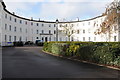
The Crescent, Horton Road, Gloucester
Now restored and converted into residential accommodation formerly this was the Victorian Lunatic Asylum (in the 21st century a very un-PC name).
Image: © Philip Halling
Taken: 1 Feb 2014
0.06 miles
5
![Gloucester buildings [15]](https://s1.geograph.org.uk/geophotos/06/58/06/6580685_af62dc86_120x120.jpg)
Gloucester buildings [15]
This is part of the main block of the Horton Road Hospital which opened in 1823 as the First Gloucestershire County Asylum. There were many later 19th century alterations and additions, principally wings and blocks. The hospital closed in 1988 and was converted to housing in 2005. Described by English Heritage as 'An outstanding early 19th century hospital complex, particularly notable for its advanced plan form, constructional techniques and fine neo-classical facade.' Listed, grade II*, with details at: https://historicengland.org.uk/listing/the-list/list-entry/1271680
The cathedral city and county town of Gloucestershire, Gloucester lies on the River Severn and is linked via the Gloucester and Sharpness Canal to the river’s estuary. Founded by the Romans in AD 97, the city gained its first charter in 1155. In the Middle Ages there were a large number of monastic establishments including St Peter's Abbey founded in 679 - later Gloucester Cathedral. Until the construction of the Severn Bridge in 1966, Gloucester was the lowest road bridging point on the River Severn. The city has a long association with the aerospace business, including the Gloster Aircraft Company.
Image: © Michael Dibb
Taken: 1 Jun 2020
0.06 miles
6
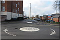
Mayhill Way
Mayhill Way off Horton Road gives access to the Gloucestershire Royal Hospital. The tall the chimney is a prominent feature on the Gloucester skyline.
Image: © Philip Halling
Taken: 1 Feb 2014
0.08 miles
7

Collingwood Crescent
Originally part of the Gloucester Hospital this has now been sold off to developers and is being converted into flats.
Image: © David Stowell
Taken: 18 Sep 2005
0.08 miles
8
![Gloucester houses [12]](https://s0.geograph.org.uk/geophotos/06/58/06/6580660_16a64c47_120x120.jpg)
Gloucester houses [12]
This fine house, Collingwood House in Horton Road, was built in red brick circa 1835. It was the house of the Governor of the Horton Road Hospital. Now used as a training and education centre for the NHS. Listed, grade II, with details at: https://historicengland.org.uk/listing/the-list/list-entry/1271679
The cathedral city and county town of Gloucestershire, Gloucester lies on the River Severn and is linked via the Gloucester and Sharpness Canal to the river’s estuary. Founded by the Romans in AD 97, the city gained its first charter in 1155. In the Middle Ages there were a large number of monastic establishments including St Peter's Abbey founded in 679 - later Gloucester Cathedral. Until the construction of the Severn Bridge in 1966, Gloucester was the lowest road bridging point on the River Severn. The city has a long association with the aerospace business, including the Gloster Aircraft Company.
Image: © Michael Dibb
Taken: 1 Jun 2020
0.09 miles
9
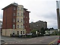
Gloucestershire Royal Hospital
Showing the A&E department to the left, the Tower ward block on the right, and the helipad in the foreground.
Image: © Jonathan Billinger
Taken: 5 Jan 2007
0.09 miles
10
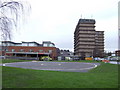
![Gloucester Royal Hospital [1]](https://s1.geograph.org.uk/geophotos/06/58/07/6580745_198c3d70_120x120.jpg)
Gloucester Royal Hospital [1]
The Tower Block.
The 683 bed District General Hospital was opened in 1914. Completely rebuilt in the 1960s with an 11-storey tower added in 1975. A major expansion was completed in 2005.
The cathedral city and county town of Gloucestershire, Gloucester lies on the River Severn and is linked via the Gloucester and Sharpness Canal to the river’s estuary. Founded by the Romans in AD 97, the city gained its first charter in 1155. In the Middle Ages there were a large number of monastic establishments including St Peter's Abbey founded in 679 - later Gloucester Cathedral. Until the construction of the Severn Bridge in 1966, Gloucester was the lowest road bridging point on the River Severn. The city has a long association with the aerospace business, including the Gloster Aircraft Company.
Image: © Michael Dibb
Taken: 1 Jun 2020
0.09 miles