IMAGES TAKEN NEAR TO
London Road, GLOUCESTER, GL1 3HN
Introduction
This page details the photographs taken nearby to London Road, GL1 3HN by members of the Geograph project.
The Geograph project started in 2005 with the aim of publishing, organising and preserving representative images for every square kilometre of Great Britain, Ireland and the Isle of Man.

There are currently over 7.5m images from over14,400 individuals and you can help contribute to the project by visiting https://www.geograph.org.uk
Image Map
Images are licensed for reuse under creativecommons.org/licenses/by-sa/2.0
Notes
- Clicking on the map will re-center to the selected point.
- The higher the marker number, the further away the image location is from the centre of the postcode.
Image Listing (170 Images Found)
Images are licensed for reuse under creativecommons.org/licenses/by-sa/2.0
Image
Details
Distance
1
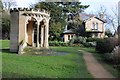
The King's Board and Hillfield Gardens
The King's Board is thought to be 14th century in origin and reputed to have been given to the City of Gloucester by King Richard II, and was used as a butter market in the late 16th century. The King's Board now stands in Hillfield Gardens beside London Road where it was placed in 1937. Originally it was a preaching cross standing in Westgate Street in the heart of Gloucester; it was later used as a butter market. It was removed from Westgate Street in 1750 and was placed in two further locations in Gloucester before going to Tibberton Court for a century. It is a Grade II listed structure. Between the arches there are carved biblical scenes. Image] Image] Image] Image] Image] Image]
Image: © Philip Halling
Taken: 1 Feb 2014
0.00 miles
2
Lodge to Hillfield House, London Road
In similar style and date (1867) to the house itself http://www.geograph.org.uk/photo/6090318 . Listed Grade II.
Image: © Alan Murray-Rust
Taken: 16 Mar 2019
0.01 miles
3
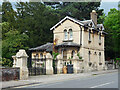
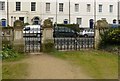
Lodge and gates, London Road, Gloucester
Italianate lodge matching the house it once served (Image]), built c1867. Good gatepiers and wrought-iron gates. Grade II listed.
Image: © Stephen Richards
Taken: 18 May 2015
0.01 miles
4
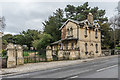
Lodge and gates to Hillfield
Lodge and gates to Hillfield House (see Image), dating from 1867, designed by John Giles and built by Charles Estcourt. The gates were fabricated by William Letheren of Cheltenham, considered to be the greatest ironwork artist in England of his time. Separately grade II listed - for the lodge see www.historicengland.org.uk/listing/the-list/list-entry/1245738 and for the gates see www.historicengland.org.uk/listing/the-list/list-entry/1245747.
Image: © Ian Capper
Taken: 16 Mar 2019
0.01 miles
5
Gateway to Hillfield House, London Road
Contemporary (c.1867) with the lodge http://www.geograph.org.uk/photo/6090362 and the house itself http://www.geograph.org.uk/photo/6090318 . Wrought iron gates with ashlar gateposts and flanking balustrades, Listed Grade II.
Image: © Alan Murray-Rust
Taken: 16 Mar 2019
0.01 miles
6
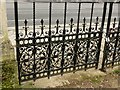
Gateway to Hillfield House, London Road
Detail of the gates, see http://www.geograph.org.uk/photo/6090373 for location.
Image: © Alan Murray-Rust
Taken: 16 Mar 2019
0.01 miles
7
![Gloucester buildings [9]](https://s3.geograph.org.uk/geophotos/06/57/94/6579451_6b079a61_120x120.jpg)
Gloucester buildings [9]
To the west of the entrance gates to Hillfield Gardens, the gate lodge was built in ashlar in Italianate style circa 1867. Hillfield Gardens was formerly the large suburban garden to Hillfield House. Listed, grade II, with details at: https://historicengland.org.uk/listing/the-list/list-entry/1245738
The ashlar gate piers and corner piers, the balustrade and the wrought-iron gates form the entrance to Hillfield Gardens, formerly the large suburban garden to Hillfield House. Listed, grade II, with details at: https://historicengland.org.uk/listing/the-list/list-entry/1245747
The cathedral city and county town of Gloucestershire, Gloucester lies on the River Severn and is linked via the Gloucester and Sharpness Canal to the river’s estuary. Founded by the Romans in AD 97, the city gained its first charter in 1155. In the Middle Ages there were a large number of monastic establishments including St Peter's Abbey founded in 679 - later Gloucester Cathedral. Until the construction of the Severn Bridge in 1966, Gloucester was the lowest road bridging point on the River Severn. The city has a long association with the aerospace business, including the Gloster Aircraft Company.
Image: © Michael Dibb
Taken: 1 Jun 2020
0.01 miles
8
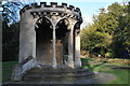
The King's Board
The King's Board now stands in Hillfield Gardens where it was placed in 1937. Originally it was a preaching cross standing in Westgate Street in the heart of Gloucester; it was later used as a butter market. It was removed from Westgate Street in 1750 and was placed in two further locations in Gloucester before going to Tibberton Court for a century.
Image: © Philip Halling
Taken: 26 Feb 2011
0.02 miles
9
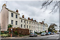
100 - 118 London Road
Stuccoed terrace on London Road, marked on old maps as Hillfield Parade, dating from around 1827. Grade II listed: for the nearest building, no 118, see www.historicengland.org.uk/listing/the-list/list-entry/1245741 - for the far building, nos 100 and 102, see www.historicengland.org.uk/listing/the-list/list-entry/1245737 - and for the terrace in between, nos 104 - 116, see www.historicengland.org.uk/listing/the-list/list-entry/1245739.
Image: © Ian Capper
Taken: 16 Mar 2019
0.02 miles
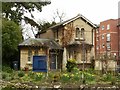
10
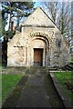
Remains of the Chapel of St Mary Magdalen
All that remains of the Chapel of St Mary Magdalen is the chancel. The chapel was built in the 12th century in a Norman and style and served the nearby St Mary Magdalen's Hospital which was probably founded for lepers. The nave of the chapel was demolished in 1861, while the hospital buildings were demolished soon afterwards.
Image: © Philip Halling
Taken: 1 Feb 2014
0.02 miles