IMAGES TAKEN NEAR TO
Sherborne Street, GLOUCESTER, GL1 3EA
Introduction
This page details the photographs taken nearby to Sherborne Street, GL1 3EA by members of the Geograph project.
The Geograph project started in 2005 with the aim of publishing, organising and preserving representative images for every square kilometre of Great Britain, Ireland and the Isle of Man.

There are currently over 7.5m images from over14,400 individuals and you can help contribute to the project by visiting https://www.geograph.org.uk
Image Map
Images are licensed for reuse under creativecommons.org/licenses/by-sa/2.0
Notes
- Clicking on the map will re-center to the selected point.
- The higher the marker number, the further away the image location is from the centre of the postcode.
Image Listing (328 Images Found)
Images are licensed for reuse under creativecommons.org/licenses/by-sa/2.0
Image
Details
Distance
1
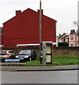
Sherborne Street phonebox, Gloucester
BT phonebox on grass near the corner of Oxford Road.
Image: © Jaggery
Taken: 26 Jan 2020
0.04 miles
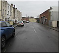
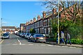
2
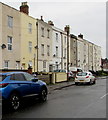
Row of three-storey housing, Oxford Street, Gloucester
Looking towards the Sherborne Street/Henry Street crossroads.
Image: © Jaggery
Taken: 26 Jan 2020
0.04 miles
3
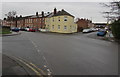
Gloucester crossroads
Viewed from the NE end of Oxford Street.
Sherborne Street is on the left.
Oxford Road is ahead.
Henry Street is on the right.
Image: © Jaggery
Taken: 26 Jan 2020
0.04 miles
4
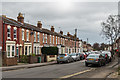
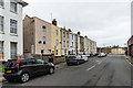
Oxford Road
Late Victorian terraced villas in Oxford Road.
Image: © Ian Capper
Taken: 16 Mar 2019
0.05 miles
5
Oxford Street, Gloucester
Looking to the northeast along Oxford Street towards the Sherborne Street/Henry Street/Oxford Road crossroads.
The rear of Stagecoach Gloucester Bus Depot https://www.geograph.org.uk/photo/6376680 is on the right.
Image: © Jaggery
Taken: 26 Jan 2020
0.05 miles
6
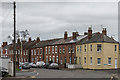
33 - 53 Oxford Street
Early 19th Century terrace in Oxford Street. The building on the left is part of nos 29 - 31 Oxford Street which was built in 1823-25 and is grade II listed - see www.historicengland.org.uk/listing/the-list/list-entry/1245677.
Image: © Ian Capper
Taken: 16 Mar 2019
0.05 miles
7
Oxford Road
Late Victorian terraced housing in Oxford Road.
Image: © Ian Capper
Taken: 16 Mar 2019
0.05 miles
8
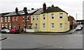
Houses at the southern end of Oxford Road, Gloucester
The corner of Henry Street is on the right.
Image: © Jaggery
Taken: 26 Jan 2020
0.05 miles
9
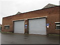
Oxford Street side of Stagecoach Gloucester Bus Depot
The rear entrance to this https://www.geograph.org.uk/photo/6376485 bus depot alongside the B4063 London Road in Gloucester.
Image: © Jaggery
Taken: 26 Jan 2020
0.06 miles
10
Gloucester : Henry Street
Looking along Henry Street from Oxford Road.
Image: © Lewis Clarke
Taken: 2 Apr 2023
0.06 miles