IMAGES TAKEN NEAR TO
Sherborne Street, GLOUCESTER, GL1 3BY
Introduction
This page details the photographs taken nearby to Sherborne Street, GL1 3BY by members of the Geograph project.
The Geograph project started in 2005 with the aim of publishing, organising and preserving representative images for every square kilometre of Great Britain, Ireland and the Isle of Man.

There are currently over 7.5m images from over14,400 individuals and you can help contribute to the project by visiting https://www.geograph.org.uk
Image Map
Images are licensed for reuse under creativecommons.org/licenses/by-sa/2.0
Notes
- Clicking on the map will re-center to the selected point.
- The higher the marker number, the further away the image location is from the centre of the postcode.
Image Listing (360 Images Found)
Images are licensed for reuse under creativecommons.org/licenses/by-sa/2.0
Image
Details
Distance
1
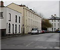
33 - 53 Oxford Street
Early 19th Century terrace in Oxford Street. The building on the left is part of nos 29 - 31 Oxford Street which was built in 1823-25 and is grade II listed - see www.historicengland.org.uk/listing/the-list/list-entry/1245677.
Image: © Ian Capper
Taken: 16 Mar 2019
0.04 miles
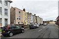
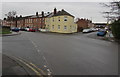
2
Row of three-storey housing, Oxford Street, Gloucester
Looking towards the Sherborne Street/Henry Street crossroads.
Image: © Jaggery
Taken: 26 Jan 2020
0.04 miles
3
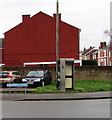
Sherborne Street phonebox, Gloucester
BT phonebox on grass near the corner of Oxford Road.
Image: © Jaggery
Taken: 26 Jan 2020
0.04 miles
4
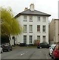
29/31 Oxford Street, Gloucester
Pair of semi-detached houses. 1823-5, minor later C19 alterations. Part of the development of Oxford Street for John Bowyer, attorney, Listed Grade II.
Image: © Alan Murray-Rust
Taken: 16 Mar 2019
0.05 miles
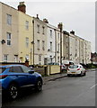
5
Oxford Street housing, Gloucester
Two and three storey buildings viewed across London Road.
Image: © Jaggery
Taken: 26 Jan 2020
0.05 miles
6
![Gloucester houses [4]](https://s3.geograph.org.uk/geophotos/06/57/76/6577627_d07dcc29_120x120.jpg)
Gloucester houses [4]
This pair of semi-detached houses, numbers 29 and 31 Oxford Street, was built in 1823/5 as part of the development of the area. The conservatory at the side of number 29 is 20th century. Listed, grade II, with details at: https://historicengland.org.uk/listing/the-list/list-entry/1245677
The cathedral city and county town of Gloucestershire, Gloucester lies on the River Severn and is linked via the Gloucester and Sharpness Canal to the river’s estuary. Founded by the Romans in AD 97, the city gained its first charter in 1155. In the Middle Ages there were a large number of monastic establishments including St Peter's Abbey founded in 679 - later Gloucester Cathedral. Until the construction of the Severn Bridge in 1966, Gloucester was the lowest road bridging point on the River Severn. The city has a long association with the aerospace business, including the Gloster Aircraft Company.
Image: © Michael Dibb
Taken: 1 Jun 2020
0.05 miles
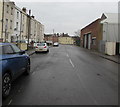
7
Gloucester crossroads
Viewed from the NE end of Oxford Street.
Sherborne Street is on the left.
Oxford Road is ahead.
Henry Street is on the right.
Image: © Jaggery
Taken: 26 Jan 2020
0.05 miles
8
Oxford Street, Gloucester
Looking to the northeast along Oxford Street towards the Sherborne Street/Henry Street/Oxford Road crossroads.
The rear of Stagecoach Gloucester Bus Depot https://www.geograph.org.uk/photo/6376680 is on the right.
Image: © Jaggery
Taken: 26 Jan 2020
0.05 miles
9
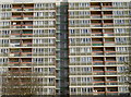
Clapham Court
This lofty, ten storey block of high-rise homes was built in 1990, to provide eighty one-bedroom sheltered housing flats. See Image] for a look at the latest improvements.
Image: © Neil Owen
Taken: 17 Feb 2015
0.05 miles
10
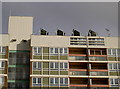
Topped off with technology
The top of Clapham Court appears to be benefiting from the hottest of high-rise high-tech - solar panels.
Image: © Neil Owen
Taken: 17 Feb 2015
0.05 miles