IMAGES TAKEN NEAR TO
Sunnybrook Terrace, BERKELEY, GL13 9UW
Introduction
This page details the photographs taken nearby to Sunnybrook Terrace, GL13 9UW by members of the Geograph project.
The Geograph project started in 2005 with the aim of publishing, organising and preserving representative images for every square kilometre of Great Britain, Ireland and the Isle of Man.

There are currently over 7.5m images from over14,400 individuals and you can help contribute to the project by visiting https://www.geograph.org.uk
Image Map
Images are licensed for reuse under creativecommons.org/licenses/by-sa/2.0
Notes
- Clicking on the map will re-center to the selected point.
- The higher the marker number, the further away the image location is from the centre of the postcode.
Image Listing (75 Images Found)
Images are licensed for reuse under creativecommons.org/licenses/by-sa/2.0
Image
Details
Distance
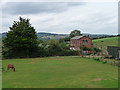
2
Route of former railway towards the Severn Bridge, Sharpness
Image: © Gareth James
Taken: 30 Apr 2011
0.04 miles
3
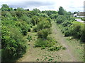
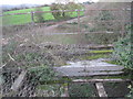
Former trackbed of the Severn Bridge Railway
Image: © Tim Glover
Taken: 26 May 2011
0.05 miles
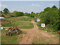
4
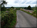
Severn Way crosses former railway line
The Severn Way crosses this bridge on its way through Sharpness Docks. The bridge used to provide passage over the Severn & Wye Railway. The building was subject at the time for a planning application to convert its usage from a nursing home to offices and to replace the original wooden windows with UPVC.
Image: © Tim Glover
Taken: 26 May 2011
0.07 miles
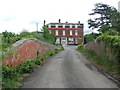
7
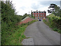
The former Severn Bridge and Railway Hotel
Dates from about the time of the opening of the railway to Lydney in 1879.
Image: © Jonathan Thacker
Taken: 21 Nov 2013
0.08 miles
8
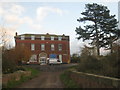
Former hotel at Sharpness
Former hotel, now a business premises at Sharpness.
Image: © Philip Halling
Taken: 15 Apr 2012
0.08 miles
9
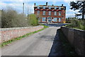
Detail for former railway bridge
Part of the bridge is still in use by pedestrians.
Image: © Jonathan Thacker
Taken: 21 Nov 2013
0.08 miles
10
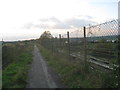
Path to the swing bridge
That this was a former railway is evident from the disused section to the right.
Image: © Jonathan Thacker
Taken: 21 Nov 2013
0.09 miles