IMAGES TAKEN NEAR TO
Hamfields, BERKELEY, GL13 9TL
Introduction
This page details the photographs taken nearby to GL13 9TL by members of the Geograph project.
The Geograph project started in 2005 with the aim of publishing, organising and preserving representative images for every square kilometre of Great Britain, Ireland and the Isle of Man.

There are currently over 7.5m images from over14,400 individuals and you can help contribute to the project by visiting https://www.geograph.org.uk
Image Map
Images are licensed for reuse under creativecommons.org/licenses/by-sa/2.0
Notes
- Clicking on the map will re-center to the selected point.
- The higher the marker number, the further away the image location is from the centre of the postcode.
Image Listing (14 Images Found)
Images are licensed for reuse under creativecommons.org/licenses/by-sa/2.0
Image
Details
Distance
1
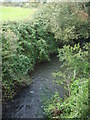
The Berkeley Pill
The small stream looks pretty innocuous but in times past it was a navigable waterway that brought ships to the village of Berkeley.
Image: © Neil Owen
Taken: 4 Sep 2020
0.05 miles
2
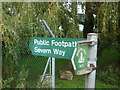
This way to the Severn Way
The path crosses the Berkeley Pill at the Lynch Road bridge.
Image: © Neil Owen
Taken: 4 Sep 2020
0.05 miles
3
View to Berkeley Power Station
View to Berkeley Power Station with the course of Berkeley Pill in the foreground.
Image: © Philip Halling
Taken: 24 Jan 2015
0.09 miles
4
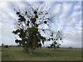
Some mistletoe in September
Given the recent stormy weather it's not too much of a shock to see some early season mistletoe. This tree appears to be particularly imbued.
Image: © Neil Owen
Taken: 4 Sep 2020
0.10 miles
5
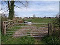
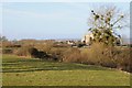
Field beside Berkeley Pill
Berkeley Pill, the continuation of the Little Avon River, is obscured by a levee just beyond the circular feeder. Seen from Hamfield Lane.
Image: © Derek Harper
Taken: 30 Mar 2009
0.11 miles
7
Trees laden with mistletoe by Lynch Rd Ind Est, Berkeley
Image: © Colin Park
Taken: 2 Dec 2018
0.13 miles
8

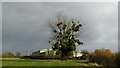
Lone tree at sunset
In the arable land to the north of Berkeley Pill is this lone tree (an alder?) covered with clumps of mistletoe. The sun is going down for the last time in 2009.
Image: © Graham Horn
Taken: 31 Dec 2009
0.16 miles
9
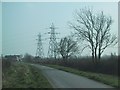
Powerlines cross the road near Berkeley Power station
Image: © Sarah Charlesworth
Taken: 20 Mar 2009
0.18 miles
10
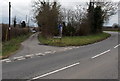
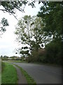
Oakhunger Lane, Berkeley
Looking west across Lynch Road. Oakhunger Lane is not a through route.
Image: © Jaggery
Taken: 10 Mar 2013
0.20 miles