IMAGES TAKEN NEAR TO
Hook Street, BERKELEY, GL13 9TH
Introduction
This page details the photographs taken nearby to Hook Street, GL13 9TH by members of the Geograph project.
The Geograph project started in 2005 with the aim of publishing, organising and preserving representative images for every square kilometre of Great Britain, Ireland and the Isle of Man.

There are currently over 7.5m images from over14,400 individuals and you can help contribute to the project by visiting https://www.geograph.org.uk
Image Map
Images are licensed for reuse under creativecommons.org/licenses/by-sa/2.0
Notes
- Clicking on the map will re-center to the selected point.
- The higher the marker number, the further away the image location is from the centre of the postcode.
Image Listing (13 Images Found)
Images are licensed for reuse under creativecommons.org/licenses/by-sa/2.0
Image
Details
Distance
1
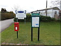
Postbox outside Berkeley Vale Park
Also in view are a Hamfallow Parish Council noticeboard and a Berkeley Vale Park (park homes) information board.
Image: © Jaggery
Taken: 10 Mar 2013
0.08 miles
2
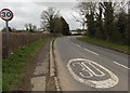
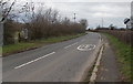
Start of the 30mph speed limit west of Berkeley
On the approach to Hook Street.
Image: © Jaggery
Taken: 10 Mar 2013
0.09 miles
3
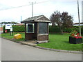
Hook Street bus shelter near Berkeley
Located near the entrance to Berkeley Vale Park (park homes), for buses to the centre of Berkeley.
Image: © Jaggery
Taken: 10 Mar 2013
0.09 miles
4
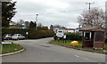
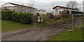
Entrance to Hook Street
A large temporary home park has grown up around the area.
Image: © Neil Owen
Taken: 4 Sep 2020
0.09 miles
5
End of the 30mph zone west of Berkeley
The 30mph zone ends at National Speed Limit signs near the Oakhunger Lane junction. http://www.geograph.org.uk/photo/4096381
Image: © Jaggery
Taken: 10 Mar 2013
0.09 miles

7
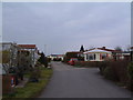
Berkeley Vale Park
A Mobile Homes park at Hook Street, Berkeley, looking east.
Image: © David Exworth
Taken: 11 Mar 2006
0.11 miles
8
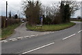
Oakhunger Lane, Berkeley
Looking west across Lynch Road. Oakhunger Lane is not a through route.
Image: © Jaggery
Taken: 10 Mar 2013
0.11 miles
9
Southern entrance to Lynch Vale Caravan Park, Berkeley
From Lynch Road. 5-bar gate and muddy track on the right, small wooden gate and a path on the left.
Image: © Jaggery
Taken: 10 Mar 2013
0.13 miles
10
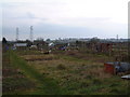
Oakhunger Lane Allotments, Hook Street
Berkeley's allotments are in the hamlet of Hook Street, half a mile west of the town centre. This view is looking south, over the allotments towards the ridge of the mediaeval Whitcliff Deer Park. The Pylons carried electricity from the nearby (de-commissioned) Berkeley Nuclear Power Station.
Image: © David Exworth
Taken: 11 Mar 2006
0.14 miles