IMAGES TAKEN NEAR TO
Stambourne Lane, BERKELEY, GL13 9RZ
Introduction
This page details the photographs taken nearby to Stambourne Lane, GL13 9RZ by members of the Geograph project.
The Geograph project started in 2005 with the aim of publishing, organising and preserving representative images for every square kilometre of Great Britain, Ireland and the Isle of Man.

There are currently over 7.5m images from over14,400 individuals and you can help contribute to the project by visiting https://www.geograph.org.uk
Image Map
Images are licensed for reuse under creativecommons.org/licenses/by-sa/2.0
Notes
- Clicking on the map will re-center to the selected point.
- The higher the marker number, the further away the image location is from the centre of the postcode.
Image Listing (7 Images Found)
Images are licensed for reuse under creativecommons.org/licenses/by-sa/2.0
Image
Details
Distance
1
Houses at Wanswell
The backs of houses viewed from a footpath at Wanswell.
Image: © Philip Halling
Taken: 15 Apr 2012
0.12 miles
2
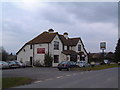
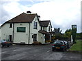
The Lamastide Inn
As can be seen from the number of card in the car park at Saturday lunchtime, this is a popular pub between the twin hamlets of Brookend and New Brookend.
Image: © David Exworth
Taken: 11 Mar 2006
0.14 miles
3
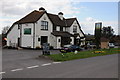
Lammastide Inn
The Lammastide Inn at Wanswell.
Image: © Philip Halling
Taken: 15 Apr 2012
0.17 miles

6
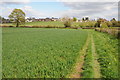
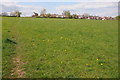
Footpath at Wanswell
Footpath between Newtown and Wanswell.
Image: © Philip Halling
Taken: 15 Apr 2012
0.19 miles
7

Oilseed rape at Wanswell
The unmistakeble bright flower of oilseed rape in a field at Wanswell.
Image: © Philip Halling
Taken: 15 Apr 2012
0.20 miles