IMAGES TAKEN NEAR TO
Wanswell, BERKELEY, GL13 9RR
Introduction
This page details the photographs taken nearby to GL13 9RR by members of the Geograph project.
The Geograph project started in 2005 with the aim of publishing, organising and preserving representative images for every square kilometre of Great Britain, Ireland and the Isle of Man.

There are currently over 7.5m images from over14,400 individuals and you can help contribute to the project by visiting https://www.geograph.org.uk
Image Map
Images are licensed for reuse under creativecommons.org/licenses/by-sa/2.0
Notes
- Clicking on the map will re-center to the selected point.
- The higher the marker number, the further away the image location is from the centre of the postcode.
Image Listing (9 Images Found)
Images are licensed for reuse under creativecommons.org/licenses/by-sa/2.0
Image
Details
Distance
2
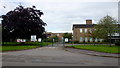
Focus School, Berkeley Campus
Focus is a group of affiliated independent schools run by the Plymouth Brethren, see; http://www.plymouthbrethrenchristianchurch.org/education/our-schools/united-kingdom-ireland/
Image: © Jonathan Billinger
Taken: 31 Jul 2017
0.07 miles
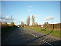
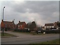
3
Main Road, Wanswell
Looking north from next to the entrance of Focus School, Image
Image: © Jonathan Billinger
Taken: 31 Jul 2017
0.09 miles
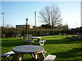

6
Wanswell
The focus of Wanswell is the local pub, The Salmon, seen here with neighbouring 19th century houses. The pub garden is almost like a village green. The minor road leading to the houses is Rookery Lane.
Image: © David Exworth
Taken: 11 Mar 2006
0.14 miles
7
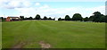
Oldlands Cricket Club
Situated about one mile north of the large village of Berkeley.
Image: © Jonathan Billinger
Taken: 31 Jul 2017
0.18 miles
8
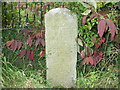
Abwell milestone
One for the connoisseurs! Off the unclassified road from Berkeley to Purton, nowadays down a lane on a loop off the current road, against garden railings. Other Berkeley milestones seem to have been defaced during WW2; this escaped, perhaps because it was so obscure. Why did the original road take this loop? Did the 19C landowner object & was powerful?
Milestone Society description:
Carved stone post by the UC road, in parish of HAMFALLOW (STROUD District), Abwell, in old road loop, opposite sports ground, against garden railings, on North side of road. Erected by the Berkley & Dursley (Division) turnpike trust in the 19th century.
Inscription reads:- : TO / BERKELEY / 1 / MILE :
Carved benchmark front middle.
Milestone Society National ID: GL_BKPT01
Image: © Mike Faherty
Taken: 19 Oct 2008
0.21 miles
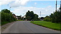
9
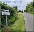
Halmore Lane in Wanswell
A village in the Vale of Berkeley.
Image: © Mat Fascione
Taken: 27 Aug 2024
0.23 miles