IMAGES TAKEN NEAR TO
Bevington, BERKELEY, GL13 9RB
Introduction
This page details the photographs taken nearby to GL13 9RB by members of the Geograph project.
The Geograph project started in 2005 with the aim of publishing, organising and preserving representative images for every square kilometre of Great Britain, Ireland and the Isle of Man.

There are currently over 7.5m images from over14,400 individuals and you can help contribute to the project by visiting https://www.geograph.org.uk
Image Map
Images are licensed for reuse under creativecommons.org/licenses/by-sa/2.0
Notes
- Clicking on the map will re-center to the selected point.
- The higher the marker number, the further away the image location is from the centre of the postcode.
Image Listing (4 Images Found)
Images are licensed for reuse under creativecommons.org/licenses/by-sa/2.0
Image
Details
Distance
1
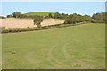
Rounded hill at Bevington
View of a rounded hill at Bevington. Beyond the field is a track and bridleway named Pennyhay Lane on the OS map.
Image: © Philip Halling
Taken: 29 Sep 2012
0.13 miles
3
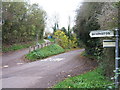
The junction for Bevington
This road junction is quite challenging to negotiate when turning right up the hill into the side-road, as can be seen by the necessity of having an extra curve of tarmac inset into the verge to enable an easier course to be followed.
Image: © Ruth Riddle
Taken: 26 Nov 2011
0.20 miles