IMAGES TAKEN NEAR TO
Clapton, BERKELEY, GL13 9QZ
Introduction
This page details the photographs taken nearby to GL13 9QZ by members of the Geograph project.
The Geograph project started in 2005 with the aim of publishing, organising and preserving representative images for every square kilometre of Great Britain, Ireland and the Isle of Man.

There are currently over 7.5m images from over14,400 individuals and you can help contribute to the project by visiting https://www.geograph.org.uk
Image Map
Images are licensed for reuse under creativecommons.org/licenses/by-sa/2.0
Notes
- Clicking on the map will re-center to the selected point.
- The higher the marker number, the further away the image location is from the centre of the postcode.
Image Listing (6 Images Found)
Images are licensed for reuse under creativecommons.org/licenses/by-sa/2.0
Image
Details
Distance
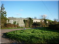
2
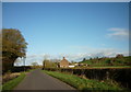
Stubble field and Clapton Farm
View across a stubble field near Bevington in the Vale of Berkeley.
Image: © Philip Halling
Taken: 29 Sep 2012
0.06 miles
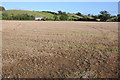
3
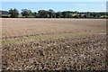
Stubble field near Bevington
A stubble field and farmland in the Vale of Berkeley near Bevington.
Image: © Philip Halling
Taken: 29 Sep 2012
0.11 miles
4
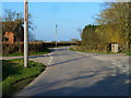
Crossroads at Willis Elm, near Berkeley
Image: © Ruth Sharville
Taken: 4 Mar 2011
0.12 miles
6
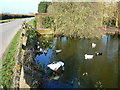
Duckpond at Willis Elm, near Berkeley
Image: © Ruth Sharville
Taken: 4 Mar 2011
0.14 miles