IMAGES TAKEN NEAR TO
Clapton, BERKELEY, GL13 9QU
Introduction
This page details the photographs taken nearby to GL13 9QU by members of the Geograph project.
The Geograph project started in 2005 with the aim of publishing, organising and preserving representative images for every square kilometre of Great Britain, Ireland and the Isle of Man.

There are currently over 7.5m images from over14,400 individuals and you can help contribute to the project by visiting https://www.geograph.org.uk
Image Map
Images are licensed for reuse under creativecommons.org/licenses/by-sa/2.0
Notes
- Clicking on the map will re-center to the selected point.
- The higher the marker number, the further away the image location is from the centre of the postcode.
Image Listing (7 Images Found)
Images are licensed for reuse under creativecommons.org/licenses/by-sa/2.0
Image
Details
Distance
1
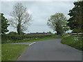
Junction with Woodlands Lane
Woodlands Lane, the turning to Woodlands Farm, leaves the road between Hill and Ham at this point.
Image: © Ruth Riddle
Taken: 19 May 2012
0.03 miles
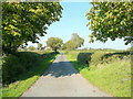
3
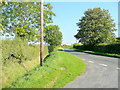
Road to Bluegates
The Ham road winds its way towards Berkeley.
Image: © Jonathan Billinger
Taken: 30 Sep 2011
0.04 miles
4
Track near Woodlands Farm
Track near Woodlands Farm which can be seen to the left, also visible is Berkeley nuclear power station.
Image: © Philip Halling
Taken: 29 Sep 2012
0.04 miles
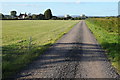
5
Lane to Woodlands Farm
Heading north, the lane is public access only to just beyond the farm.
Image: © Jonathan Billinger
Taken: 30 Sep 2011
0.06 miles
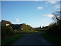
6
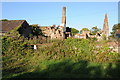
Ruined farm buildings near Bevington
Image: © Philip Halling
Taken: 29 Sep 2012
0.07 miles
7
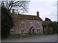
Woodlands Farm, Berkeley
An isolated farm in the Vale of Berkeley
Image: © David Exworth
Taken: 13 Mar 2006
0.16 miles