IMAGES TAKEN NEAR TO
Blackhall, BERKELEY, GL13 9QS
Introduction
This page details the photographs taken nearby to GL13 9QS by members of the Geograph project.
The Geograph project started in 2005 with the aim of publishing, organising and preserving representative images for every square kilometre of Great Britain, Ireland and the Isle of Man.

There are currently over 7.5m images from over14,400 individuals and you can help contribute to the project by visiting https://www.geograph.org.uk
Image Map
Images are licensed for reuse under creativecommons.org/licenses/by-sa/2.0
Notes
- Clicking on the map will re-center to the selected point.
- The higher the marker number, the further away the image location is from the centre of the postcode.
Image Listing (6 Images Found)
Images are licensed for reuse under creativecommons.org/licenses/by-sa/2.0
Image
Details
Distance
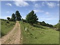
1
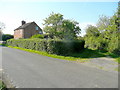
Parham Lane
Adjacent to the green lane is Blackhall Cottage on the Ham Road.
Image: © Jonathan Billinger
Taken: 30 Sep 2011
0.03 miles
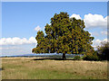
2
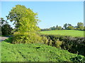
Golden Ash
Looking east on a fine autumn afternoon by the entrance to Parham Lane.
Image: © Jonathan Billinger
Taken: 30 Sep 2011
0.06 miles
3
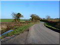
Road scene east of entrance to Parham Lane
Image: © Ruth Sharville
Taken: 4 Mar 2011
0.08 miles
4
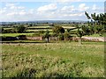
Whitcliff Park boundary wall
The deer park was first enclosed as a medieval deer park at the end of the 13th century. The current brick wall which surrounds the park was started in 1770 and took 7 years to complete.
The land seen outside the boundary wall are in the neighbouring grid squares.
Image: © Linda Bailey
Taken: 24 Sep 2006
0.13 miles
6
Horsechestnut Tree at Whitcliff Park
Whitcliff Park is a Deer Park, and there is a footpath which runs through the park, along the ridge which forms the parkland. This horsechestnut tree (Aesculus hippocastanum) was set back from the path.
Image: © Linda Bailey
Taken: 24 Sep 2006
0.23 miles