IMAGES TAKEN NEAR TO
Heathfield, BERKELEY, GL13 9PW
Introduction
This page details the photographs taken nearby to Heathfield, GL13 9PW by members of the Geograph project.
The Geograph project started in 2005 with the aim of publishing, organising and preserving representative images for every square kilometre of Great Britain, Ireland and the Isle of Man.

There are currently over 7.5m images from over14,400 individuals and you can help contribute to the project by visiting https://www.geograph.org.uk
Image Map
Images are licensed for reuse under creativecommons.org/licenses/by-sa/2.0
Notes
- Clicking on the map will re-center to the selected point.
- The higher the marker number, the further away the image location is from the centre of the postcode.
Image Listing (6 Images Found)
Images are licensed for reuse under creativecommons.org/licenses/by-sa/2.0
Image
Details
Distance
2
Grubby direction sign 1 mile from Blanchworth
Pointing towards a minor road, the sign facing the A38 in Gloucestershire
is 1 mile from Blanchworth, 2½ from Stinchcombe, 3 from North Nibley.
Image: © Jaggery
Taken: 15 Oct 2023
0.16 miles
3
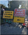
A38, Heatfhfield
The minor road leads to Kitt's Green Farm
Image: © David Dixon
Taken: 2 Mar 2012
0.16 miles
4
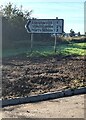
Typo on a temporary sign in rural Gloucestershire
Temporary signs across a minor road face the A38 in October 2023.
NURSARY is a typo for NURSERY
Image: © Jaggery
Taken: 15 Oct 2023
0.16 miles
5
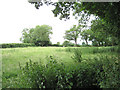
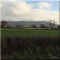
Narrow field east of A38, Berkeley Heath: 1
Image: © Robin Stott
Taken: 18 Jun 2010
0.19 miles
6
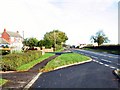
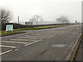
Heathfield
A view north up the A38 as it passes through the hamlet of Heathfield.
Image: © Roger May
Taken: 9 Nov 2005
0.20 miles