IMAGES TAKEN NEAR TO
Oldminster Road, BERKELEY, GL13 9NA
Introduction
This page details the photographs taken nearby to Oldminster Road, GL13 9NA by members of the Geograph project.
The Geograph project started in 2005 with the aim of publishing, organising and preserving representative images for every square kilometre of Great Britain, Ireland and the Isle of Man.

There are currently over 7.5m images from over14,400 individuals and you can help contribute to the project by visiting https://www.geograph.org.uk
Image Map
Images are licensed for reuse under creativecommons.org/licenses/by-sa/2.0
Notes
- Clicking on the map will re-center to the selected point.
- The higher the marker number, the further away the image location is from the centre of the postcode.
Image Listing (34 Images Found)
Images are licensed for reuse under creativecommons.org/licenses/by-sa/2.0
Image
Details
Distance
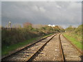
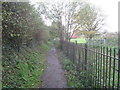
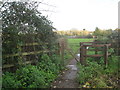
6
Footpath crossing the railway, Newtown
Image: © Jonathan Thacker
Taken: 21 Nov 2013
0.10 miles
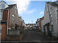
9
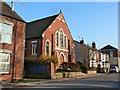
Union church, Newtown, Sharpness
This is the United Reformed church.
Image: © Ruth Sharville
Taken: 4 Mar 2011
0.12 miles
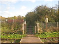
10
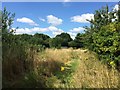
Footpath to Newtown
Links the docks entrance to Newtown.
Image: © Jonathan Thacker
Taken: 21 Nov 2013
0.14 miles