IMAGES TAKEN NEAR TO
Ham, BERKELEY, GL13 9LP
Introduction
This page details the photographs taken nearby to GL13 9LP by members of the Geograph project.
The Geograph project started in 2005 with the aim of publishing, organising and preserving representative images for every square kilometre of Great Britain, Ireland and the Isle of Man.

There are currently over 7.5m images from over14,400 individuals and you can help contribute to the project by visiting https://www.geograph.org.uk
Image Map
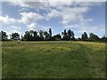
Images are licensed for reuse under creativecommons.org/licenses/by-sa/2.0
Notes
- Clicking on the map will re-center to the selected point.
- The higher the marker number, the further away the image location is from the centre of the postcode.
Image Listing (22 Images Found)
Images are licensed for reuse under creativecommons.org/licenses/by-sa/2.0
Image
Details
Distance
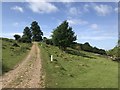
1

Gate and track, Ham
The indicates this gate provides access to a farmland track.
Image: © Philip Halling
Taken: 29 Sep 2012
0.07 miles
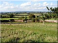
3
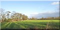
Field and trees south of Ham
The trees on the left line an overgrown track to Ham
Image: © David Smith
Taken: 29 Dec 2017
0.12 miles
4
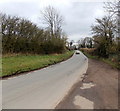
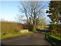
Minor road from Ham to Pedington Elm
Rural Gloucestershire south of Berkeley.
Image: © Jaggery
Taken: 10 Mar 2013
0.13 miles
6
Access road to Tanhouse Farm
The entrance still has a platform for milk churns
Image: © David Smith
Taken: 29 Dec 2017
0.15 miles
7
Whitcliff Park boundary wall
The deer park was first enclosed as a medieval deer park at the end of the 13th century. The current brick wall which surrounds the park was started in 1770 and took 7 years to complete.
The land seen outside the boundary wall are in the neighbouring grid squares.
Image: © Linda Bailey
Taken: 24 Sep 2006
0.17 miles
8

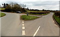
Junction of two minor roads, Ham
Viewed from the edge of this grass triangle http://www.geograph.org.uk/photo/3895688
Ahead for Clapton and Bevington. The road on the left is from Pedington Elm.
Image: © Jaggery
Taken: 10 Mar 2013
0.17 miles
9
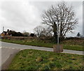
Grass triangle at a junction south of Ham, Gloucestershire
At the junction of two minor roads. A temporary white-on-black notice
on the signpost shows Hill Fun Run Sunday 10th March (2013) @ 12 noon.
Image: © Jaggery
Taken: 10 Mar 2013
0.17 miles
10
Left for Berkeley, right for Stone near Ham
The signpost is on a grass triangle here. http://www.geograph.org.uk/photo/3895688 The Ham village boundary sign http://www.geograph.org.uk/photo/3895671 is on the left.
Image: © Jaggery
Taken: 10 Mar 2013
0.17 miles