IMAGES TAKEN NEAR TO
Berkeley Road, BERKELEY, GL13 9HB
Introduction
This page details the photographs taken nearby to Berkeley Road, GL13 9HB by members of the Geograph project.
The Geograph project started in 2005 with the aim of publishing, organising and preserving representative images for every square kilometre of Great Britain, Ireland and the Isle of Man.

There are currently over 7.5m images from over14,400 individuals and you can help contribute to the project by visiting https://www.geograph.org.uk
Image Map
Images are licensed for reuse under creativecommons.org/licenses/by-sa/2.0
Notes
- Clicking on the map will re-center to the selected point.
- The higher the marker number, the further away the image location is from the centre of the postcode.
Image Listing (25 Images Found)
Images are licensed for reuse under creativecommons.org/licenses/by-sa/2.0
Image
Details
Distance
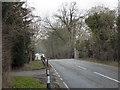
3
Bend in the A38 on the approach to Leathern Bottle
Viewed from the B4066 (Berkeley Road) junction. The buildings in the distance
are part of Hengaston Farm near Leathern Bottle.
Image: © Jaggery
Taken: 21 Jul 2012
0.13 miles
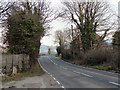
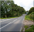
4
The A38 north of Berkeley Road
For much of the length of the M5 motorway between Birmingham and Exeter the A38 runs parallel, often becoming clogged with traffic whenever there is an accident or holdup on the M5. The A38 is the longest two digit road in Britain, running 309 miles between Bodmin in Cornwall and Mansfield in Nottinghamshire.
Image: © Philip Halling
Taken: 16 Feb 2016
0.13 miles
5
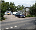
Dursley Auto Dismantlers
The car breakers' premises is about 4km NW of Dursley town centre, at the western end
of Berkeley Road (B4066) near the A38 junction and the Prince of Wales hotel. http://www.geograph.org.uk/photo/3047509
Image: © Jaggery
Taken: 21 Jul 2012
0.13 miles
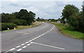
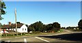
6
Berkeley Road heads away from the A38 near the Prince of Wales hotel
The B4066 (Berkeley Road) heads towards Cam.
The Prince of Wales Hotel http://www.geograph.org.uk/photo/3047509 is nearby, on the south side of the A38.
Image: © Jaggery
Taken: 21 Jul 2012
0.13 miles
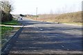
8
The A38 west of The Quarry, Gloucestershire
Image: © nick macneill
Taken: 14 Oct 2012
0.16 miles
9
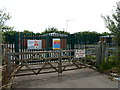
Wales & West Utilities GVC near Berkeley Road
Located on the south side of the B4066. GVC is Gas Valve Compound. Among the many instructions on a notice on the gates are CAUTION Dangerous substances on site; Nomex overalls must be worn; safety glasses, safety shoes and safety helmets must be worn. Another notice shows Smoking and naked flames prohibited. The letters EX inside a yellow triangle indicate explosive atmosphere.
Image: © Jaggery
Taken: 21 Jul 2012
0.16 miles
10
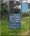
Rockhampton Folk Festival information board near Berkeley
On the corner of Berkeley Road and the A38 Bristol Road in June 2024.
The Prince of Wales Hotel https://www.geograph.org.uk/photo/7808457 is in the background.
Image: © Jaggery
Taken: 16 Jun 2024
0.17 miles