IMAGES TAKEN NEAR TO
Stump Street, BERKELEY, GL13 9FG
Introduction
This page details the photographs taken nearby to Stump Street, GL13 9FG by members of the Geograph project.
The Geograph project started in 2005 with the aim of publishing, organising and preserving representative images for every square kilometre of Great Britain, Ireland and the Isle of Man.

There are currently over 7.5m images from over14,400 individuals and you can help contribute to the project by visiting https://www.geograph.org.uk
Image Map
Images are licensed for reuse under creativecommons.org/licenses/by-sa/2.0
Notes
- Clicking on the map will re-center to the selected point.
- The higher the marker number, the further away the image location is from the centre of the postcode.
Image Listing (30 Images Found)
Images are licensed for reuse under creativecommons.org/licenses/by-sa/2.0
Image
Details
Distance
1
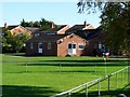
Station Road, home of Berkeley Town Football Club
The team play in the Gloucestershire County Football League.
Image: © nick macneill
Taken: 14 Oct 2012
0.07 miles
2
Stand, Station Road, Berkeley Town Football Club
Image: © nick macneill
Taken: 14 Oct 2012
0.12 miles
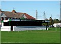
3
Football stand, Canon Park, Berkeley
20 metre long stand at the western (Station Road) edge of Canon Park,
home ground of Berkeley Town Football Club.
Image: © Jaggery
Taken: 10 Mar 2013
0.12 miles
4
Berrycroft, Berkeley
Viewed from the Station Road end looking towards The Leys.
Image: © Jaggery
Taken: 10 Mar 2013
0.12 miles
5
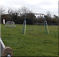
Children's play area in Canon Park, Berkeley
In the NW corner of Canon Park, viewed from Station Road.
Image: © Jaggery
Taken: 10 Mar 2013
0.12 miles
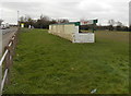
6
Canon Park
Home to Berkeley Town football club, who play in the Gloucestershire Northern Senior League. Formed in 1898, the ambitious club have recently taken on a 25-year lease and started to improve the clubhouse.
Image: © Neil Owen
Taken: 4 Sep 2020
0.12 miles
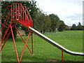
7
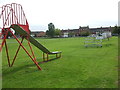
Berkeley Recreation Ground
The town's football ground and also containing some play equipment.
Image: © Neil Owen
Taken: 4 Sep 2020
0.12 miles
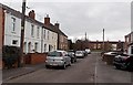
8
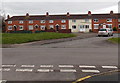
The Leys, Berkeley
Houses on the east side of The Leys, viewed from the corner of Berrycroft.
Image: © Jaggery
Taken: 10 Mar 2013
0.13 miles
9
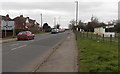
Approaching the B4066 roundabout from the south, Berkeley
Looking north along Station Road. A football stand http://www.geograph.org.uk/photo/3987652 is on the right.
Image: © Jaggery
Taken: 10 Mar 2013
0.13 miles
10
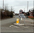
Northern boundary of Berkeley
Viewed along Station Road at the B4066 junction. The Berkeley boundary sign is on the left, above the 30mph speed limit sign. Berkeley is a small town in the Stroud administrative district, Gloucestershire.
Image: © Jaggery
Taken: 10 Mar 2013
0.13 miles