IMAGES TAKEN NEAR TO
The Brambles, BERKELEY, GL13 9EF
Introduction
This page details the photographs taken nearby to The Brambles, GL13 9EF by members of the Geograph project.
The Geograph project started in 2005 with the aim of publishing, organising and preserving representative images for every square kilometre of Great Britain, Ireland and the Isle of Man.

There are currently over 7.5m images from over14,400 individuals and you can help contribute to the project by visiting https://www.geograph.org.uk
Image Map
Images are licensed for reuse under creativecommons.org/licenses/by-sa/2.0
Notes
- Clicking on the map will re-center to the selected point.
- The higher the marker number, the further away the image location is from the centre of the postcode.
Image Listing (176 Images Found)
Images are licensed for reuse under creativecommons.org/licenses/by-sa/2.0
Image
Details
Distance
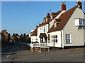
1
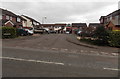
The Brambles, Berkeley
Houses on the east side of Station Road.
Image: © Jaggery
Taken: 10 Mar 2013
0.02 miles
2
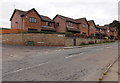
Watts Close, Berkeley
Viewed across Station Road. Watts Close is a row of five houses on the corner of Fitzhardinge Way.
Image: © Jaggery
Taken: 10 Mar 2013
0.04 miles
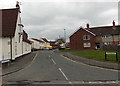
3
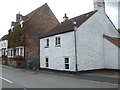
Marybrook Street
A view along one of Berkeley's chief thoroughfares, with a white cottage dating from the eighteenth century and before most of the other houses. A rivet benchmark was made in the concrete apron in front of the cottage - see Image
Image: © Neil Owen
Taken: 4 Sep 2020
0.05 miles
4
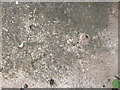
A lost rivet on Marybrook Street
This poor benchmark used to have a rivet as its reference point but appears to have lost it. See https://www.bench-marks.org.uk/bm108466 for the entry in the Benchmark Database and Image] for a wider view.
Image: © Neil Owen
Taken: 4 Sep 2020
0.05 miles
6
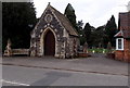
Cemetery chapel, Berkeley
At the eastern (Station Road) edge of the cemetery. The edge of the cemetery lodge is on the right.
Image: © Jaggery
Taken: 10 Mar 2013
0.06 miles
7
Lower Berrycroft, Berkeley
From Marybrook Street. The edge of the Malt House http://www.geograph.org.uk/photo/3987493 is on the left.
Image: © Jaggery
Taken: 10 Mar 2013
0.06 miles
8
Berkeley cemetery
The cemetery has been accepting funerals for well over a century, when it was in a quiet part of the countryside and a distance from the town. The mortuary chapel is on the left, the lodge on the right.
Image: © Neil Owen
Taken: 4 Sep 2020
0.07 miles
9
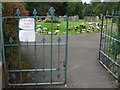
Please leave the gate open!
Not the normal sort of message at Berkeley cemetery. The Covid-19 impositions have come to this.
Image: © Neil Owen
Taken: 4 Sep 2020
0.07 miles
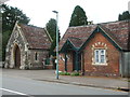
10
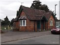
Cemetery lodge, Berkeley
At the eastern (Station Road) edge of the cemetery.
The cemetery chapel http://www.geograph.org.uk/photo/3987536 is a couple of metres out of shot on the left.
Image: © Jaggery
Taken: 10 Mar 2013
0.07 miles