IMAGES TAKEN NEAR TO
Marybrook Street, BERKELEY, GL13 9BA
Introduction
This page details the photographs taken nearby to Marybrook Street, GL13 9BA by members of the Geograph project.
The Geograph project started in 2005 with the aim of publishing, organising and preserving representative images for every square kilometre of Great Britain, Ireland and the Isle of Man.

There are currently over 7.5m images from over14,400 individuals and you can help contribute to the project by visiting https://www.geograph.org.uk
Image Map
Images are licensed for reuse under creativecommons.org/licenses/by-sa/2.0
Notes
- Clicking on the map will re-center to the selected point.
- The higher the marker number, the further away the image location is from the centre of the postcode.
Image Listing (195 Images Found)
Images are licensed for reuse under creativecommons.org/licenses/by-sa/2.0
Image
Details
Distance
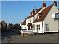
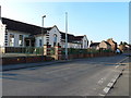
1
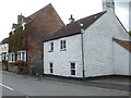
Marybrook Street
A view along one of Berkeley's chief thoroughfares, with a white cottage dating from the eighteenth century and before most of the other houses. A rivet benchmark was made in the concrete apron in front of the cottage - see Image
Image: © Neil Owen
Taken: 4 Sep 2020
0.02 miles
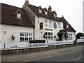
4
The Malt House Hotel
Standing in Berkeley for over a century.
Image: © Neil Owen
Taken: 4 Sep 2020
0.02 miles
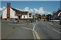
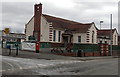
6
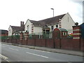
Berkeley Primary School
The town's school stands on Marybrook Street, but has a slightly more convoluted history. Originally, the school was founded in 1861 and was known as the Fitzharding School, located by the castle. The building seen here is from 1910 and used to house the Secondary Modern School, but a growing population (especially during the construction of the nuclear power station) in the 1960s forced the pupils to move to a new site. The primary school took over in 1964.
A free school also used to be on the same street before the Edwardian building was built.
Image: © Neil Owen
Taken: 4 Sep 2020
0.02 miles
7
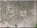
A lost rivet on Marybrook Street
This poor benchmark used to have a rivet as its reference point but appears to have lost it. See https://www.bench-marks.org.uk/bm108466 for the entry in the Benchmark Database and Image] for a wider view.
Image: © Neil Owen
Taken: 4 Sep 2020
0.03 miles
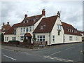
8
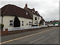
Malt House, Berkeley
Viewed across Marybrook Street.
The Malt House is a family-run hotel & restaurant on the corner of Lower Berrycroft.
Image: © Jaggery
Taken: 10 Mar 2013
0.03 miles
10
Berkeley Primary School
Viewed across the corner of Marybrook Street and School Lane.
Image: © Jaggery
Taken: 10 Mar 2013
0.03 miles