IMAGES TAKEN NEAR TO
Longsmith Street, GLOUCESTER, GL1 2TS
Introduction
This page details the photographs taken nearby to Longsmith Street, GL1 2TS by members of the Geograph project.
The Geograph project started in 2005 with the aim of publishing, organising and preserving representative images for every square kilometre of Great Britain, Ireland and the Isle of Man.

There are currently over 7.5m images from over14,400 individuals and you can help contribute to the project by visiting https://www.geograph.org.uk
Image Map
Images are licensed for reuse under creativecommons.org/licenses/by-sa/2.0
Notes
- Clicking on the map will re-center to the selected point.
- The higher the marker number, the further away the image location is from the centre of the postcode.
Image Listing (1988 Images Found)
Images are licensed for reuse under creativecommons.org/licenses/by-sa/2.0
Image
Details
Distance
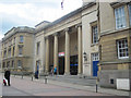
1
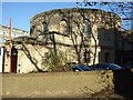
Crown Court, Gloucester
The Crown Court is part of the rear of Shirew Hall in Gloucester; it was built in 1816 and designed by Robert Smirke. The building is Grade II listed. https://historicengland.org.uk/listing/the-list/list-entry/1271573
Image: © Philip Halling
Taken: 1 Dec 2017
0.01 miles
2
Court at the rear of Shire Hall, Longsmith Road, Gloucester
Image: © David Smith
Taken: 25 Nov 2016
0.01 miles
3
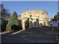
Crown Court, Longsmith Street, Gloucester
Not many buildings have a plan comprising of two nine-sided polygons (semi-octadecagons?) projecting from a rectangle. From where Robert Smirke drew inspiration is not clear. Built c1815, though altered in the C20th to suit modern functions. Grade II listed.
Image: © Stephen Richards
Taken: 17 May 2015
0.01 miles
4

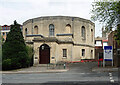
Crown Court, Gloucester
Located on Longsmith Street, the Crown Court deals with criminal cases.
Image: © Pauline E
Taken: 19 Oct 2008
0.01 miles
5
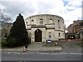
Gloucester Crown Court
Appears to be twelve sided from this angle - like the new pound coin, or old threepeny bit.
Image: © Richard Webb
Taken: 16 Apr 2016
0.01 miles
6
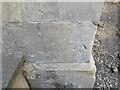
Ordnance Survey Cut Mark
This OS cut mark can be found on the south angle of the Shire Hall. It marks a point 14.620m above mean sea level.
Image: © Adrian Dust
Taken: 9 Jul 2022
0.01 miles
7
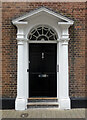
Detail of 18 Berkeley Street, Gloucester
Late C18th doorcase with a pretty fanlight.
Wider view: Image
Image: © Stephen Richards
Taken: 17 May 2015
0.02 miles
8
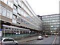
Gloucester Shire Hall
Classic 1960's municipal architecture.
Image: © Jonathan Billinger
Taken: 5 Jan 2007
0.02 miles
10

Berkeley Street, Gloucester
The building with the red door is the former fire station. See Image
Image: © Pauline E
Taken: 19 Oct 2008
0.02 miles