IMAGES TAKEN NEAR TO
Fairview Caravan Site, Pool Meadow, GLOUCESTER, GL1 2SB
Introduction
This page details the photographs taken nearby to Fairview Caravan Site, Pool Meadow, GL1 2SB by members of the Geograph project.
The Geograph project started in 2005 with the aim of publishing, organising and preserving representative images for every square kilometre of Great Britain, Ireland and the Isle of Man.

There are currently over 7.5m images from over14,400 individuals and you can help contribute to the project by visiting https://www.geograph.org.uk
Image Map
Images are licensed for reuse under creativecommons.org/licenses/by-sa/2.0
Notes
- Clicking on the map will re-center to the selected point.
- The higher the marker number, the further away the image location is from the centre of the postcode.
Image Listing (54 Images Found)
Images are licensed for reuse under creativecommons.org/licenses/by-sa/2.0
Image
Details
Distance
1
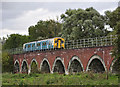
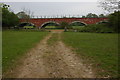
Pool Meadow Viaduct
150 285 on the 17:45 service from Cheltenham to Maesteg crossing Pool Meadow Viaduct. This floods fairly regularly in winter when the Severn bursts its banks.
Image: © Stuart Wilding
Taken: 4 Sep 2009
0.07 miles
2
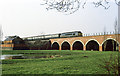
St Catherine's Viaduct
A Class 45 diesel (45149) runs onto the viaduct on its approach to Gloucester with a train from South Wales. In the foreground is a boating lake and on the left, next to the railway line, is a pump house which presumably was built to return water to the East Channel of the River Severn after flooding.
Image: © Martin Addison
Taken: Unknown
0.08 miles
4
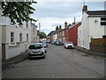
Westend Parade - Gloucester, Gloucestershire
Here on the right bank of the River Severn, on the other side of the river from the city of Gloucester, is this enclave of houses and the Showmans Winter Quarters. Some 19th century homes here and others more modern in these three streets – Alney Terrace, Westend Parade and Westend Terrace. Some of my happiest years were spent here, living in Westend Terrace, from 1985 – 2004 and I was tempted to make a return here when a house came up for sale in Westend Parade but the area has been and possibly still is at high risk of flooding. Passing on the north-east side is the Nottingham – Cardiff railway line and immediately fronting on the south is the A417 Ledbury – Gloucester road which replaced the former main route into Gloucester via Telford's Over Bridge. Time photo taken 4.19 pm BST (British Summer Time).
Image: © Martin Richard Phelan
Taken: 8 Sep 2017
0.10 miles
5
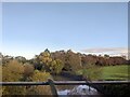
Railway viaduct, Alney Island, Gloucester
Image: © Philip Halling
Taken: 22 Apr 2007
0.12 miles
6
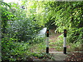
Alney Island hazard - Gloucester, Gloucestershire
Very definitely there is no way through here. Time photo taken 4.03 pm BST (British Summer Time).
Image: © Martin Richard Phelan
Taken: 8 Sep 2017
0.13 miles
8
Westend Terrace again - Gloucester, Gloucestershire
Another view of Westend Terrace, taken from the southern end of Westend Parade. The building nearest the camera is the former Riverside Hotel, now converted into six flats. Time photo taken 4.15 pm BST (British Summer Time).
Image: © Martin Richard Phelan
Taken: 8 Sep 2017
0.13 miles
9
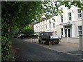
Westend Terrace - Gloucester, Gloucestershire
A view of Westend Terrace, one of the three streets in this enclave on the west bank of the River Severn, the others being Westend Parade and Alney Terrace. The houses here date from the 19th century with a few more modern ones. Here also is a caravan park - the Showmen's Winter Quarters. Here from the mid 1980s until 2004 was where I lived in a second floor bedsit - some of the happiest years of my life. In one year, during floods, there were people travelling in boats along this cul de sac. The area, being so close to the Severn, is subject to repeated flooding which put me off making a return here though, sadly. Time photo taken 4.14 pm BST (British Summer Time).
Image: © Martin Richard Phelan
Taken: 8 Sep 2017
0.13 miles
10
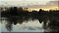
Twyver floods, 4
The dim outline of Severnside Farm can be made out against the dark outline of the trees of Town Ham Wood.
Image: © Jonathan Billinger
Taken: 10 Feb 2014
0.13 miles