IMAGES TAKEN NEAR TO
Lower Quay Street, GLOUCESTER, GL1 2JX
Introduction
This page details the photographs taken nearby to Lower Quay Street, GL1 2JX by members of the Geograph project.
The Geograph project started in 2005 with the aim of publishing, organising and preserving representative images for every square kilometre of Great Britain, Ireland and the Isle of Man.

There are currently over 7.5m images from over14,400 individuals and you can help contribute to the project by visiting https://www.geograph.org.uk
Image Map
Images are licensed for reuse under creativecommons.org/licenses/by-sa/2.0
Notes
- Clicking on the map will re-center to the selected point.
- The higher the marker number, the further away the image location is from the centre of the postcode.
Image Listing (1457 Images Found)
Images are licensed for reuse under creativecommons.org/licenses/by-sa/2.0
Image
Details
Distance
1
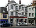
The Lower George Inn, Westgate Street, Gloucester
Stuccoed pub, dated c1840. Grade II listed.
Image: © Stephen Richards
Taken: 17 May 2015
0.01 miles
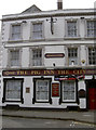
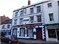
2
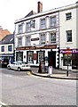
The Pig Inn the City, 121 Westgate Street
This popular public house is one of the few in the City of Gloucester to offer regular live music. Update March 2019:- Now known as The Lower George Inn, after a change of ownership. See:- Image
Image: © P L Chadwick
Taken: 6 Jul 2009
0.01 miles
3
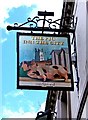
The Pig Inn the City pub sign, 121 Westgate Street
An amusing pun which was apparently "Inn Spired". Image
Image: © P L Chadwick
Taken: 6 Jul 2009
0.01 miles
4
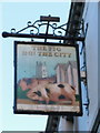
The Pig Inn the City
When this pub closed down the manager moved down the road to manage the Old Crown for Sam Smith's Brewery.
Image: © Ian S
Taken: 23 May 2013
0.02 miles

6
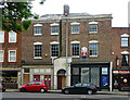
The Lower George Inn (1), 121 Westgate Street, Gloucester
This public house, formerly a hotel, has had a number of names over its long history. For much of it the business was known as The Lower George Hotel, but in recent years it was The Pig Inn the City. Now it is The Lower George Inn. When it was a Mad O’Rourke's pub in the late 1990's it was painted a bright orange and green. It has been owned by various breweries including Stroud Brewery.
The building is much older than it looks. Originally a merchant's house dating from the 16th century, it has later alterations including a front façade which hides the original timber frame. On the upper floors and in the roof there is or was exposed timber framing. The building is Grade II listed.
Image
Image
Image: © P L Chadwick
Taken: 16 Mar 2019
0.02 miles
7
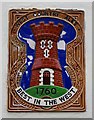
The Lower George Inn (2) - brewery plaque, 121 Westgate Street, Gloucester
Despite changes of name & ownership over the years, this pub has managed to retain this West Country Ales plaque, although it is damaged in places. The ceramic plaque is affixed to the front wall of the pub. It was first used by the Gloucestershire brewers, West Country Breweries, who were an amalgamation of others, two of whom commenced brewing in 1760. The plaques were placed by West Country Breweries on their pubs between 1958 and 1963, when Whitbreads took them over. Whitbreads continued to use the castle logo and to install these plaques, for a few years after the takeover until about 1967. There are still quite a few around, with some variation of colour, and in two sizes. At other times the pub was owned by the Stroud Brewery and much later by Banks's Brewery of Wolverhampton.
Image
Image: © P L Chadwick
Taken: 16 Mar 2019
0.02 miles
8
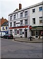
109-111 Westgate Street, Gloucester
Early C19th, built as a pair of shops. Grade II listed.
Image: © Stephen Richards
Taken: 17 May 2015
0.02 miles
9
The Pig's had its bacon
A much-loved pub, with several CAMRA awards to its name, went out of business in October 2011. The landlord went across the road to the Crown Inn and there have not been any takers to carry on with this one.
Image: © Neil Owen
Taken: 11 Aug 2012
0.02 miles
10
The Pig Inn the City
When this pub closed down the manager moved down the road to manage the Old Crown for Sam Smith's Brewery.
Image: © Ian S
Taken: 23 May 2013
0.02 miles