IMAGES TAKEN NEAR TO
Bearland, GLOUCESTER, GL1 2JP
Introduction
This page details the photographs taken nearby to Bearland, GL1 2JP by members of the Geograph project.
The Geograph project started in 2005 with the aim of publishing, organising and preserving representative images for every square kilometre of Great Britain, Ireland and the Isle of Man.

There are currently over 7.5m images from over14,400 individuals and you can help contribute to the project by visiting https://www.geograph.org.uk
Image Map
Images are licensed for reuse under creativecommons.org/licenses/by-sa/2.0
Notes
- Clicking on the map will re-center to the selected point.
- The higher the marker number, the further away the image location is from the centre of the postcode.
Image Listing (1996 Images Found)
Images are licensed for reuse under creativecommons.org/licenses/by-sa/2.0
Image
Details
Distance
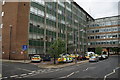
1
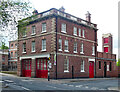
Police Station
The row of tidily parked police cars was what caught my eye here.
Image: © Anne Burgess
Taken: 7 Jul 2014
0.01 miles
2
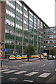
Office block on Longsmith Street
I believe this building was part of the police station, it appears to have undergone a facelift, I'm not sure if it still is. As appears to be the practice these days, 'cladding' has been applied. Here's the same building in 2014 Image
Image: © Philip Halling
Taken: 1 Dec 2017
0.01 miles
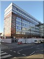
4
Shire Hall, Bearland, Gloucester
The rear of the main E-W block, by R.F. Fairhurst, County Architect, with Gilbert Jones, c1966. The view has since vanished as the building has been re-clad, and the intervening ground built on. The front used to look like this: Image
Still the head offices of Gloucestershire County Council.
Image: © Stephen Richards
Taken: 19 May 2015
0.01 miles
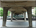
5
Court at the rear of Shire Hall, Longsmith Road, Gloucester
Image: © David Smith
Taken: 25 Nov 2016
0.02 miles
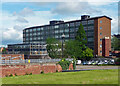
6
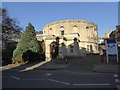
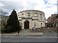
Crown Court, Longsmith Street, Gloucester
Not many buildings have a plan comprising of two nine-sided polygons (semi-octadecagons?) projecting from a rectangle. From where Robert Smirke drew inspiration is not clear. Built c1815, though altered in the C20th to suit modern functions. Grade II listed.
Image: © Stephen Richards
Taken: 17 May 2015
0.02 miles
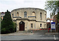
7
Gloucester Crown Court
Appears to be twelve sided from this angle - like the new pound coin, or old threepeny bit.
Image: © Richard Webb
Taken: 16 Apr 2016
0.02 miles
8
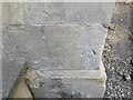
Ordnance Survey Cut Mark
This OS cut mark can be found on the south angle of the Shire Hall. It marks a point 14.620m above mean sea level.
Image: © Adrian Dust
Taken: 9 Jul 2022
0.02 miles
9
Former fire station, Longsmith Street, Gloucester
By Deputy City Surveyor, E.W.A. Carter, 1912-13. It forms a wing to Bearland House.
Now offices.
Image: © Stephen Richards
Taken: 19 May 2015
0.02 miles
10
Detail of Shire Hall, Bearland, Gloucester
An "impressive and exciting link" between blocks across Bearland.
Wider view: Image
Image: © Stephen Richards
Taken: 17 May 2015
0.02 miles