IMAGES TAKEN NEAR TO
Barbican Way, GLOUCESTER, GL1 2JG
Introduction
This page details the photographs taken nearby to Barbican Way, GL1 2JG by members of the Geograph project.
The Geograph project started in 2005 with the aim of publishing, organising and preserving representative images for every square kilometre of Great Britain, Ireland and the Isle of Man.

There are currently over 7.5m images from over14,400 individuals and you can help contribute to the project by visiting https://www.geograph.org.uk
Image Map
Images are licensed for reuse under creativecommons.org/licenses/by-sa/2.0
Notes
- Clicking on the map will re-center to the selected point.
- The higher the marker number, the further away the image location is from the centre of the postcode.
Image Listing (2079 Images Found)
Images are licensed for reuse under creativecommons.org/licenses/by-sa/2.0
Image
Details
Distance
1

Gloucester castle and gaol
Informative plaque on the prison wall in Barbican Road.
Image: © Pauline E
Taken: 19 Oct 2008
0.01 miles
2
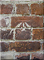
Mark on the Nick
A benchmark on the outer wall of the old Gloucester prison, running along the rather narrow Barbican Road. Despite the obvious application of some fresh pointing that has filled in the arrows it is still legible. See http://www.bench-marks.org.uk/bm28506 for the entry in the Benchmark Database and Image] for a wider view.
Image: © Neil Owen
Taken: 19 Jun 2013
0.02 miles
3
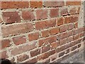
Ordnance Survey Cut Mark
This OS cut mark can be found on the wall west side of Barbican Road. It marks a point 13.230m above mean sea level.
Image: © Adrian Dust
Taken: 9 Jul 2022
0.02 miles
4
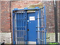
Once doors for debtors - Gloucester Prison, Gloucestershire
Having been closed some three years ago by the Ministry of Justice, the site is now in the ownership of City and Country who are to develop the site for residential use. This building dates from the original prison of 1792 and was used as a debtors prison where the living conditions could be varied according to their means. Until the prison finally closed in 2013 it was subsequently used as the healthcare wing or, less formally, the hospital. Time photo taken 1.53 pm BST (British Summer Time).
Image: © Martin Richard Phelan
Taken: 8 Sep 2017
0.02 miles
5
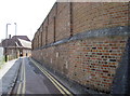
Barbican Road
The high wall is part of Gloucester Prison - hence the particularly high proportions. Near this turn and buttress is a (partly-cemented) cut benchmark - see Image
Image: © Neil Owen
Taken: 19 Jun 2013
0.02 miles
6
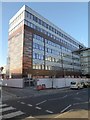
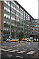
Office block on Longsmith Street
I believe this building was part of the police station, it appears to have undergone a facelift, I'm not sure if it still is. As appears to be the practice these days, 'cladding' has been applied. Here's the same building in 2014 Image
Image: © Philip Halling
Taken: 1 Dec 2017
0.02 miles
8
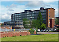
Shire Hall, Bearland, Gloucester
The rear of the main E-W block, by R.F. Fairhurst, County Architect, with Gilbert Jones, c1966. The view has since vanished as the building has been re-clad, and the intervening ground built on. The front used to look like this: Image
Still the head offices of Gloucestershire County Council.
Image: © Stephen Richards
Taken: 19 May 2015
0.03 miles
9
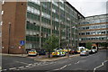
Police Station
The row of tidily parked police cars was what caught my eye here.
Image: © Anne Burgess
Taken: 7 Jul 2014
0.03 miles
10
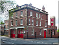
Former fire station, Longsmith Street, Gloucester
By Deputy City Surveyor, E.W.A. Carter, 1912-13. It forms a wing to Bearland House.
Now offices.
Image: © Stephen Richards
Taken: 19 May 2015
0.03 miles