IMAGES TAKEN NEAR TO
The Docks, GLOUCESTER, GL1 2EL
Introduction
This page details the photographs taken nearby to GL1 2EL by members of the Geograph project.
The Geograph project started in 2005 with the aim of publishing, organising and preserving representative images for every square kilometre of Great Britain, Ireland and the Isle of Man.

There are currently over 7.5m images from over14,400 individuals and you can help contribute to the project by visiting https://www.geograph.org.uk
Image Map
Images are licensed for reuse under creativecommons.org/licenses/by-sa/2.0
Notes
- Clicking on the map will re-center to the selected point.
- The higher the marker number, the further away the image location is from the centre of the postcode.
Image Listing (1418 Images Found)
Images are licensed for reuse under creativecommons.org/licenses/by-sa/2.0
Image
Details
Distance
1
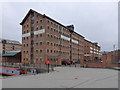
Victoria Warehouse, Gloucester Docks
Looking across the northwestern corner of Victoria Dock http://www.geograph.org.uk/photo/6095169 towards Victoria Warehouse, one of the restored warehouses on the quay between Victoria Dock and the Main Basin http://www.geograph.org.uk/photo/6095320 of Gloucester Docks. The building extending to the right from Victoria Warehouse is Herbert Warehouse, adjacent to the main basin. The building on the left is part of Britannia Warehouse.
Victoria Warehouse was built in 1849 (when Victoria Dock opened) to store imported corn. There were several corn mills http://www.geograph.org.uk/photo/6093477 in and around the docks. The warehouse was used as a corn store with some interruptions until 1989. These days, the building is used by the National Health Service for office space.
Image: © Rudi Winter
Taken: 16 Mar 2019
0.01 miles
2
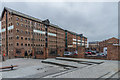
Victoria and Herbert Warehouses
Two former warehouses, Victoria Warehouse on the left (built in 1849) and Herbert Warehouse on the right (built in 1846). Herbert Warehouse is now used by Gloucester City Council. Both are grade II listed - see www.historicengland.org.uk/listing/the-list/list-entry/1245470 and www.historicengland.org.uk/listing/the-list/list-entry/1245605 respectively.
Image: © Ian Capper
Taken: 16 Mar 2019
0.01 miles
3
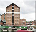
Gloucester Docks - Victoria Warehouse
Historic Gloucester Docks - 15 Victorian warehouses remain in Britain's most inland port. There are former warehouses, working dry dock, Mariners Chapel and other dock-related buildings that have been found new uses e.g. apartments, museums and restaurants.
www.visitgloucester.co.uk
Image: © Colin Smith
Taken: 31 Jul 2019
0.01 miles
4
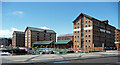
Victoria, Britannia and Albert Warehouses, The Docks, Gloucester
Victoria was built in 1849, Albert two years later, both probably by William Rees junior. Britannia, in the middle, is a 1980s rebuilding of the original after it was destroyed in a fire (hence unlisted). Grade II listed.
The restoration of Gloucester docks is a rare C20th conservation success story, largely because of the sheer number of surviving buildings but also the sympathetic way in which they have been treated. There is no gimmicky cladding, and the area has not, at least yet, been swamped by incongruous modern tat. Around fifteen warehouses, mostly built for storing grain, survive (eight have been demolished) and have been converted to offices, including for the city council, or tourist attractions.
Image: © Stephen Richards
Taken: 18 May 2015
0.01 miles
5
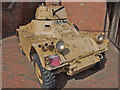
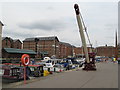
Armoured Car parked in Gloucester Docks
Parked outside a museum dedicated to the local regiment.
Image: © Chris Whippet
Taken: 4 Aug 2011
0.01 miles
6
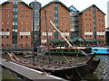
Gloucester: The Docks, Viking Boat
Vikings visited The Docks!
Image: © Alby
Taken: 25 Oct 2008
0.01 miles
7
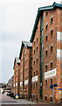
Herbert, Kimberley and Phillpotts Warehouses
The end of three former warehouses, all built in 1846 and now used as offices by Gloucester City Council. Nearest is Herbert Warehouse, then Kimberley Warehouse and beyond is Phillpotts Warehouse. All are grade II listed - see www.historicengland.org.uk/listing/the-list/list-entry/1245605, www.historicengland.org.uk/listing/the-list/list-entry/1245606 and www.historicengland.org.uk/listing/the-list/list-entry/www.historicengland.org.uk/listing/the-list/list-entry/1245606respectively.
Image: © Ian Capper
Taken: 16 Mar 2019
0.01 miles
8
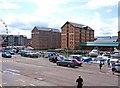
Gloucester Docks - Albert Warehouse & Britannia Warehouse
The two tall buildings are former warehouses. That on the left is Albert Warehouse, and the one on the right is Britannia Warehouse. In front of them is Victoria Basin.
Gloucester Docks are now mainly a tourist attraction, rather than a working dock. Gloucester used to be a major inland port, thanks to the Gloucester & Sharpness Ship Canal, which avoids a dangerous part of the tidal River Severn.
Image: © P L Chadwick
Taken: 6 Jul 2009
0.02 miles
10

Victoria Warehouse
Built in 1849 this was the first of three similar warehouses on the west side of the Victoria Dock. It was refurbished in 1990 and is now offices for NHS administrators.
Image: © Graham Hogg
Taken: 25 Apr 2016
0.02 miles