IMAGES TAKEN NEAR TO
Hare Lane, GLOUCESTER, GL1 2AE
Introduction
This page details the photographs taken nearby to Hare Lane, GL1 2AE by members of the Geograph project.
The Geograph project started in 2005 with the aim of publishing, organising and preserving representative images for every square kilometre of Great Britain, Ireland and the Isle of Man.

There are currently over 7.5m images from over14,400 individuals and you can help contribute to the project by visiting https://www.geograph.org.uk
Image Map
Images are licensed for reuse under creativecommons.org/licenses/by-sa/2.0
Notes
- Clicking on the map will re-center to the selected point.
- The higher the marker number, the further away the image location is from the centre of the postcode.
Image Listing (1662 Images Found)
Images are licensed for reuse under creativecommons.org/licenses/by-sa/2.0
Image
Details
Distance
1
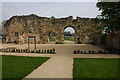
St Oswald's Priory Gloucester
This is all that remains of St Oswald's Anglo-Saxon Minster and Medieval Priory. The church was originally built around the year 900 by Aethelflaed, the daughter of Alfred the Great. The priory was dissolved in 1537 at the time of the reformation.
Image: © Philip Halling
Taken: 22 Apr 2007
0.00 miles
2
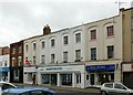
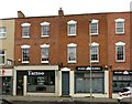
9-17, Worcester Street, Gloucester
Five terrace houses, now terrace with shops, offices and flats. 1825, with C19 and C20 alterations including conversion to shops in later C19, Listed Grade II.
Image: © Alan Murray-Rust
Taken: 16 Mar 2019
0.01 miles
3
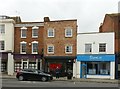
5, 7, 7A Worcester Street, Gloucester
Georgian houses, c.1825, later converted to shops. No.5 on the left is Listed Grade II.
Image: © Alan Murray-Rust
Taken: 16 Mar 2019
0.02 miles
4
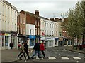
Worcester Street, Gloucester
Viewed from Northgate Street. It was a new road built in 1822 to replace narrow lanes such as Hare Lane which had provided the exit from the city towards Worcester.
Image: © Alan Murray-Rust
Taken: 16 Mar 2019
0.02 miles
5
21 and 23, Worcester Street, Gloucester
Two of three terrace houses, now two shops and dwellings. 1825, Listed Grade II.
Image: © Alan Murray-Rust
Taken: 16 Mar 2019
0.02 miles
6
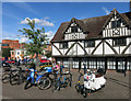
Black & White Building with Bikes
Hare Lane, quite near the cathedral but very much on the edge of the old part of town.
Image: © Des Blenkinsopp
Taken: 28 Aug 2015
0.02 miles
7
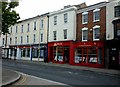
Worcester Street
Most of these premises were occupied by estate agents.
Image: © Andrew Tatlow
Taken: 15 Jul 2013
0.02 miles
8
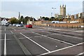
Hare Lane Car Park
The tower of Gloucester Cathedral can be seen on the right.
Image: © Philip Halling
Taken: 30 Sep 2023
0.03 miles
9
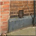
Bench mark, 25 Worcester Street, Gloucester
See http://www.geograph.org.uk/photo/6091312 for location.
Image: © Alan Murray-Rust
Taken: 16 Mar 2019
0.03 miles
10
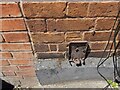
Ordnance Survey Cut Mark
This mostly hidden OS cut mark can be found on No23A Worcester Street. It marks a point 14.146m above mean sea level.
Image: © Adrian Dust
Taken: 9 Jul 2022
0.03 miles