IMAGES TAKEN NEAR TO
Russet Court, WOTTON-UNDER-EDGE, GL12 8SG
Introduction
This page details the photographs taken nearby to Russet Court, GL12 8SG by members of the Geograph project.
The Geograph project started in 2005 with the aim of publishing, organising and preserving representative images for every square kilometre of Great Britain, Ireland and the Isle of Man.

There are currently over 7.5m images from over14,400 individuals and you can help contribute to the project by visiting https://www.geograph.org.uk
Image Map
Images are licensed for reuse under creativecommons.org/licenses/by-sa/2.0
Notes
- Clicking on the map will re-center to the selected point.
- The higher the marker number, the further away the image location is from the centre of the postcode.
Image Listing (70 Images Found)
Images are licensed for reuse under creativecommons.org/licenses/by-sa/2.0
Image
Details
Distance
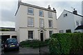
3
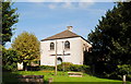
Congregational Church, Kingswood, nr Wotton Under Edge, Gloucestershire 2014
Image: © Ray Bird
Taken: 8 Sep 2014
0.07 miles
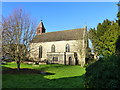
4
St Mary's Church, Kingswood, nr Wotton Under Edge, Gloucestershire 2014
Image: © Ray Bird
Taken: 8 Sep 2014
0.08 miles
5
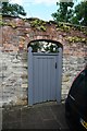
Kingswood: A garden gate
Private entrance to a garden off the High Street
Image: © Bob Harvey
Taken: 27 Aug 2015
0.08 miles
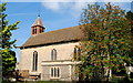
6
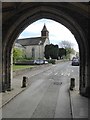
St Mary's church, Kingswood
St Mary's church, Kingswood viewed through the arch of Kingswood Abbey Gatehouse.
Image: © Philip Halling
Taken: 19 Apr 2017
0.08 miles
7
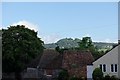
Kingswood: Looking North
The wooded knoll on the distant hilltop is the ancient hillfort of Brackenbury Ditches (Image)
Image: © Bob Harvey
Taken: 27 Aug 2015
0.09 miles
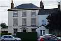
8
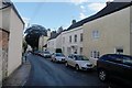
High Street, Kingswood, nr Wotton Under Edge, Gloucestershire 2014
Image: © Ray Bird
Taken: 8 Sep 2014
0.09 miles
9
Kingswood: Chipping House
A grade II listed building dating from the 18th century
See http://list.historicengland.org.uk/resultsingle.aspx?uid=1274341
Image: © Bob Harvey
Taken: 27 Aug 2015
0.09 miles
10
Kingswood: Chipping House
A grade II listed building dating from the 18th century
See http://list.historicengland.org.uk/resultsingle.aspx?uid=1274341
Image: © Bob Harvey
Taken: 27 Aug 2015
0.09 miles