IMAGES TAKEN NEAR TO
Kingswood, WOTTON-UNDER-EDGE, GL12 8RB
Introduction
This page details the photographs taken nearby to GL12 8RB by members of the Geograph project.
The Geograph project started in 2005 with the aim of publishing, organising and preserving representative images for every square kilometre of Great Britain, Ireland and the Isle of Man.

There are currently over 7.5m images from over14,400 individuals and you can help contribute to the project by visiting https://www.geograph.org.uk
Image Map
Images are licensed for reuse under creativecommons.org/licenses/by-sa/2.0
Notes
- Clicking on the map will re-center to the selected point.
- The higher the marker number, the further away the image location is from the centre of the postcode.
Image Listing (5 Images Found)
Images are licensed for reuse under creativecommons.org/licenses/by-sa/2.0
Image
Details
Distance
1
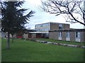
Katharine, Lady Berkeley's school
A comprehensive, situated half way between Kingswood and Wotton.
Image: © Roger Cornfoot
Taken: 19 Feb 2007
0.02 miles
4
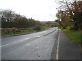
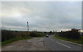
Road to Katharine Lady Berkeley's School near Wotton-under-Edge
The B4060 Wotton Road heads south away from New Road. The school entrance is out of shot around the corner ahead.
Image: © Jaggery
Taken: 28 Oct 2012
0.21 miles