IMAGES TAKEN NEAR TO
Buckover, WOTTON-UNDER-EDGE, GL12 8QJ
Introduction
This page details the photographs taken nearby to GL12 8QJ by members of the Geograph project.
The Geograph project started in 2005 with the aim of publishing, organising and preserving representative images for every square kilometre of Great Britain, Ireland and the Isle of Man.

There are currently over 7.5m images from over14,400 individuals and you can help contribute to the project by visiting https://www.geograph.org.uk
Image Map
Images are licensed for reuse under creativecommons.org/licenses/by-sa/2.0
Notes
- Clicking on the map will re-center to the selected point.
- The higher the marker number, the further away the image location is from the centre of the postcode.
Image Listing (19 Images Found)
Images are licensed for reuse under creativecommons.org/licenses/by-sa/2.0
Image
Details
Distance
1
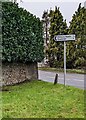
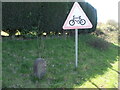
Direction sign 3 miles from Cromhall, South Gloucestershire
The sign on the corner of Cuttsheath Road and the A38
is 3 miles from Cromhall, ½ mile from Milbury Heath.
Image: © Jaggery
Taken: 1 Jan 2023
0.13 miles
2
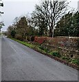
West down Cuttsheath Road, Milbury Heath
Cuttsheath Road descends towards the A38 in South Gloucestershire.
Image: © Jaggery
Taken: 1 Jan 2023
0.15 miles
3

Garden centre banners
Colourful and large near the entrance, and announcing the opening of the restaurant.
Image: © Neil Owen
Taken: 15 Apr 2021
0.15 miles
4
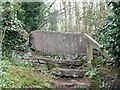
Stone Stile, A38, Thornbury GS9518
On Gloucestershire footpath OTH/114 near Milbury Heath looking looking down from the road.
The view SE towards the road is Image
Image: © Richard Laycock
Taken: 3 Apr 2021
0.15 miles
5
Stone Stile, A38, Thornbury GS9518
On Gloucestershire footpath OTH/114 near Milbury Heath looking SE towards the road.
The view looking down from the road is Image
Image: © Richard Laycock
Taken: 3 Apr 2021
0.15 miles

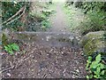
7
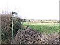
Footpath to Buckover
Off the lane near Hacket Farm
Image: © Jonathan Billinger
Taken: 15 Jan 2007
0.16 miles
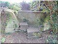
8
Stone Stile, Milbury Heath
Off Hacket Lane on Gloucestershire footpath OTH/114 looking SE.
The view NW looking to the road is Image
Image: © Richard Laycock
Taken: 3 Apr 2021
0.17 miles
9
Stone Stile, Milbury Heath
Off Hacket Lane on Gloucestershire footpath OTH/114 looking NW to the road.
The view SE is Image
Image: © Richard Laycock
Taken: 3 Apr 2021
0.17 miles
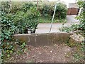
10
Milbury milestone
The A38 is the main route between Bristol and Gloucester, so it's no surprise to see one. For a closer look, see Image
Image: © Neil Owen
Taken: 15 Apr 2021
0.17 miles