IMAGES TAKEN NEAR TO
Hall End, WOTTON-UNDER-EDGE, GL12 8PD
Introduction
This page details the photographs taken nearby to GL12 8PD by members of the Geograph project.
The Geograph project started in 2005 with the aim of publishing, organising and preserving representative images for every square kilometre of Great Britain, Ireland and the Isle of Man.

There are currently over 7.5m images from over14,400 individuals and you can help contribute to the project by visiting https://www.geograph.org.uk
Image Map
Images are licensed for reuse under creativecommons.org/licenses/by-sa/2.0
Notes
- Clicking on the map will re-center to the selected point.
- The higher the marker number, the further away the image location is from the centre of the postcode.
Image Listing (13 Images Found)
Images are licensed for reuse under creativecommons.org/licenses/by-sa/2.0
Image
Details
Distance
1
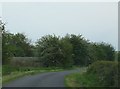
Railway beside road
Here near Hall End the railway line, with the rails just visible above the rocky trackbed, runs very closely beside the minor road for about 300m.
Image: © Ruth Riddle
Taken: 18 May 2012
0.02 miles
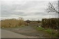
2
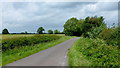
New Road, Hall End
The Bristol-Gloucester railway line unseen to the right of shot.
Image: © Jonathan Billinger
Taken: 15 Jun 2012
0.07 miles
3
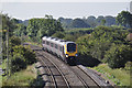
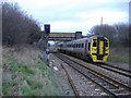
Railway at Hall End
View from the road bridge of a northbound CrossCountry Voyager at Hall End
Image: © Stuart Wilding
Taken: 25 Sep 2009
0.09 miles
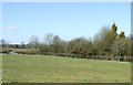
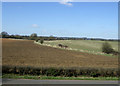
6

Hall End
Field near the railway line.
Image: © Wayland Smith
Taken: 23 Apr 2021
0.13 miles
7
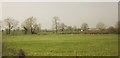
Farmland, Hall End
A view from the railway line north of Yate. The field boundary across the field runs alongside Hall End Lane.
Image: © Derek Harper
Taken: 10 Apr 2015
0.13 miles
10
Gloucester to Bristol train
Heading south, near Hall End.
Image: © Roger Cornfoot
Taken: 15 Mar 2007
0.16 miles