IMAGES TAKEN NEAR TO
Frith Lane, WOTTON-UNDER-EDGE, GL12 8PB
Introduction
This page details the photographs taken nearby to Frith Lane, GL12 8PB by members of the Geograph project.
The Geograph project started in 2005 with the aim of publishing, organising and preserving representative images for every square kilometre of Great Britain, Ireland and the Isle of Man.

There are currently over 7.5m images from over14,400 individuals and you can help contribute to the project by visiting https://www.geograph.org.uk
Image Map
Images are licensed for reuse under creativecommons.org/licenses/by-sa/2.0
Notes
- Clicking on the map will re-center to the selected point.
- The higher the marker number, the further away the image location is from the centre of the postcode.
Image Listing (6 Images Found)
Images are licensed for reuse under creativecommons.org/licenses/by-sa/2.0
Image
Details
Distance
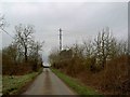
2
Frith farm
One of several huge stone farmhouses, in this area.
Image: © Roger Cornfoot
Taken: 27 Jan 2007
0.14 miles
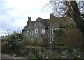
3

Frith farm gateway
An understated entrance to an impressive house.
Image: © Roger Cornfoot
Taken: 27 Jan 2007
0.16 miles
4
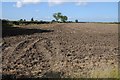
Ploughed field near Wickwar
Ploughed field to the west of Sodbury Road, south of Wickwar.
Image: © Philip Halling
Taken: 26 Sep 2015
0.21 miles
5
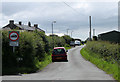
2011 : Frith Lane, seen from the B4060
No heavy vehicles, except for loading.
Rangeworthy on the B4058 in about two and a half miles.
Image: © Maurice Pullin
Taken: 21 Jun 2011
0.21 miles
6

Footpath from Frith Farm to Hillhouse Farm
Image: © Dr Duncan Pepper
Taken: 3 Jul 2013
0.24 miles