IMAGES TAKEN NEAR TO
Canters Leaze, WOTTON-UNDER-EDGE, GL12 8LX
Introduction
This page details the photographs taken nearby to Canters Leaze, GL12 8LX by members of the Geograph project.
The Geograph project started in 2005 with the aim of publishing, organising and preserving representative images for every square kilometre of Great Britain, Ireland and the Isle of Man.

There are currently over 7.5m images from over14,400 individuals and you can help contribute to the project by visiting https://www.geograph.org.uk
Image Map
Images are licensed for reuse under creativecommons.org/licenses/by-sa/2.0
Notes
- Clicking on the map will re-center to the selected point.
- The higher the marker number, the further away the image location is from the centre of the postcode.
Image Listing (4 Images Found)
Images are licensed for reuse under creativecommons.org/licenses/by-sa/2.0
Image
Details
Distance
2
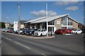
Citroen dealership
Citroen dealership on Sodbury Road in Wickwar.
Image: © Philip Halling
Taken: 26 Sep 2015
0.11 miles
3
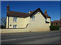
Toll House, B4060 Wickwar
Tollgate Cottage, on the NW side of the road. Originally served the Kingswood Turnpike Trust.
Milestone Society National ID: AV.WIC01
Image: © Mr Red
Taken: 15 Apr 2022
0.20 miles
4
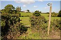
Footpath to Wickwar
Footpath to Wickwar viewed from Horwood Lane, a no through road above the Little Avon Valley.
Image: © Philip Halling
Taken: 26 Sep 2015
0.21 miles