IMAGES TAKEN NEAR TO
New Road, WOTTON-UNDER-EDGE, GL12 8JW
Introduction
This page details the photographs taken nearby to New Road, GL12 8JW by members of the Geograph project.
The Geograph project started in 2005 with the aim of publishing, organising and preserving representative images for every square kilometre of Great Britain, Ireland and the Isle of Man.

There are currently over 7.5m images from over14,400 individuals and you can help contribute to the project by visiting https://www.geograph.org.uk
Image Map
Images are licensed for reuse under creativecommons.org/licenses/by-sa/2.0
Notes
- Clicking on the map will re-center to the selected point.
- The higher the marker number, the further away the image location is from the centre of the postcode.
Image Listing (7 Images Found)
Images are licensed for reuse under creativecommons.org/licenses/by-sa/2.0
Image
Details
Distance
1
Former toll house near Wotton Under Edge
Image: © Chris Allen
Taken: 27 Oct 2013
0.03 miles
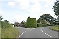
2
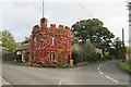
Old Toll House by New Road, Wotton under Edge
Toll House in the parish of Wotton under Edge (Stroud District), The Round House, New Road (B4058), GL12 8JW.
Grade II listed.
List Entry Number: 1367457 https://historicengland.org.uk/listing/the-list/list-entry/1367457
Surveyed
Milestone Society National ID: GL.WOT
Image: © Alan Rosevear
Taken: 21 May 2005
0.03 miles
3
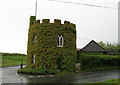
Bradley Green, tollhouse
On New Road; circular, rendered with brick crenellations. Listed by English Heritage, http://www.imagesofengland.org.uk/Details/default.aspx?pid=2&id=128207
Image: © Mike Faherty
Taken: 11 Apr 2010
0.03 miles
4
The castellated tollhouse, covered with greenery
Image: © David Smith
Taken: 15 Jun 2018
0.03 miles
5
Bradley Green, the castellated tollhouse
Image: © David Smith
Taken: 28 Jul 2012
0.04 miles
6
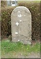
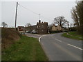
Old Milestone by the B4058, Kingswood parish
Carved stone post by the B4058, in parish of KINGSWOOD (STROUD District), just West of junction with minor road to North Nibley, by postbox, by hedge, on South side of road. Wotton stone, erected by the Wotton-under-Edge (Division) turnpike trust in the 18th century.
Inscription reads:-
I
(Mile from)
(WOTTON)
Milestone Society National ID: GL_WERY01.
Image: © M Faherty
Taken: 11 Apr 2010
0.05 miles