1
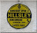
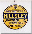
AA sign in Hillesley
It is good to see one of these increasingly rare signs. I wonder whether the spelling 'Hillsley' was current at the time, or just a mistake.
It is also intriguing to see the distance to London, more than 100 miles away and even then quite a large place, quoted to the nearer half mile. Was this to Charing Cross Station, I wonder.
Image: © David Purchase
Taken: 19 Sep 2013
0.01 miles
2
Old AA Sign, Hillesley, Gloucestershire 2014
Image: © Ray Bird
Taken: 8 Sep 2014
0.02 miles
3
The Fleece Inn, Hillesley
Image: © Philip Halling
Taken: 14 Jan 2007
0.02 miles
4
The Old Post Office, Hillesley, Gloucestershire 2014
Image: © Ray Bird
Taken: 8 Sep 2014
0.02 miles
5
St Giles Barton, Hillesley
A fairly recent development opposite St Giles church.
Image: © David Purchase
Taken: 19 Sep 2013
0.02 miles
6
The Fleece Inn, Hillesley, Gloucestershire 2014
Image: © Ray Bird
Taken: 8 Sep 2014
0.02 miles
7
Hillesley church
The church at Hillesley is dedicated to St Giles.
Image: © Philip Halling
Taken: 14 Jan 2007
0.02 miles
8
St. Giles' church, Hillesley
Image: © Ruth Sharville
Taken: 29 Nov 2014
0.02 miles
9
Old circular AA Sign on High Street, Hillesley
Old AA Sign set on a house wall on the southeast side of High Street in Hillesley, 3 miles northeast of Wickwar. Hillesley and Tresham parish.
This is the Circular, village name on black band, no Motor Union symbol or name type, dating from 1923, showing distances Hawkesbury Upton 2 Kingswood 2 London 108½.
There were five series of AA signs, mostly dating from 1923 and made by Francis & Co / Franco in Deptford, London. The village name and distance to London or Dublin were normally displayed.
See also https://www.flickr.com/photos/127982671@N06/19969505622 , https://www.flickr.com/photos/yercombe/51486264433 and https://www.flickr.com/photos/96273414@N06/15183521141.
Milestone Society National ID: GL-HILLS
Image: © Milestone Society
Taken: Unknown
0.02 miles
10
St Giles church, Hillesley
Image: © David Purchase
Taken: 19 Sep 2013
0.02 miles


