IMAGES TAKEN NEAR TO
Vicarage Lane, WOTTON-UNDER-EDGE, GL12 7RA
Introduction
This page details the photographs taken nearby to Vicarage Lane, GL12 7RA by members of the Geograph project.
The Geograph project started in 2005 with the aim of publishing, organising and preserving representative images for every square kilometre of Great Britain, Ireland and the Isle of Man.

There are currently over 7.5m images from over14,400 individuals and you can help contribute to the project by visiting https://www.geograph.org.uk
Image Map
Images are licensed for reuse under creativecommons.org/licenses/by-sa/2.0
Notes
- Clicking on the map will re-center to the selected point.
- The higher the marker number, the further away the image location is from the centre of the postcode.
Image Listing (32 Images Found)
Images are licensed for reuse under creativecommons.org/licenses/by-sa/2.0
Image
Details
Distance
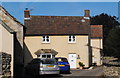
1
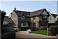
House, Kingswood Road, Hillesley, Gloucestershire 2014
Image: © Ray Bird
Taken: 8 Sep 2014
0.05 miles
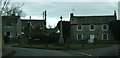
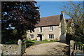
2
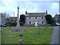
Mill House, Hillersley
Overlooking the small village green.
Image: © Roger Cornfoot
Taken: 19 Feb 2007
0.08 miles
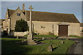
5
War Memorial, Hillesley, Gloucestershire 2014
Image: © Ray Bird
Taken: 8 Sep 2014
0.09 miles
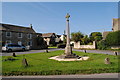
6
Hillesley War Memorial
The war memorial is located on a small triangle of grass at the junction of Alderley Road and Kingswood Road.
Image: © Ruth Riddle
Taken: 3 Mar 2012
0.09 miles
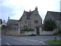
8
The Old Bakery, Hillesley, Gloucestershire 2014
Former bakery, now private house
Image: © Ray Bird
Taken: 8 Sep 2014
0.09 miles
9
Church House, Hillesley, Gloucestershire 2014
Image: © Ray Bird
Taken: 8 Sep 2014
0.09 miles
10

The Street, Hillesley, Gloucestershire 2014
Image: © Ray Bird
Taken: 8 Sep 2014
0.10 miles