IMAGES TAKEN NEAR TO
Nind Lane, WOTTON-UNDER-EDGE, GL12 7QU
Introduction
This page details the photographs taken nearby to Nind Lane, GL12 7QU by members of the Geograph project.
The Geograph project started in 2005 with the aim of publishing, organising and preserving representative images for every square kilometre of Great Britain, Ireland and the Isle of Man.

There are currently over 7.5m images from over14,400 individuals and you can help contribute to the project by visiting https://www.geograph.org.uk
Image Map
Images are licensed for reuse under creativecommons.org/licenses/by-sa/2.0
Notes
- Clicking on the map will re-center to the selected point.
- The higher the marker number, the further away the image location is from the centre of the postcode.
Image Listing (6 Images Found)
Images are licensed for reuse under creativecommons.org/licenses/by-sa/2.0
Image
Details
Distance
1
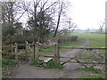
Footpath to Kingswood
Off Nind Lane
Image: © Jonathan Billinger
Taken: 30 Mar 2007
0.07 miles
2
Nind Lane
A point on the lane where two footpaths intersect.
Image: © Jonathan Billinger
Taken: 30 Mar 2007
0.09 miles
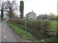
3
Nind Lane passing through Nind Farm
Looking south-west, approaching a sharp bend in the road.
Image: © Ruth Riddle
Taken: 10 Aug 2012
0.10 miles
4
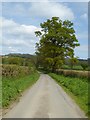
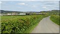
Nind Lane
Spring time on Nind Lane near Kingswood.
Image: © Philip Halling
Taken: 19 Apr 2017
0.11 miles
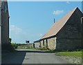
5
Country road approaching Nind Farm
Country road approaching Nind Farm near Kingswood.
Image: © Philip Halling
Taken: 19 Apr 2017
0.19 miles
6
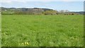
View to Wortley Hill
View across farmland near Kingswood to Wortley Hill.
Image: © Philip Halling
Taken: 19 Apr 2017
0.20 miles