IMAGES TAKEN NEAR TO
WOTTON-UNDER-EDGE, GL12 7QE
Introduction
This page details the photographs taken nearby to GL12 7QE by members of the Geograph project.
The Geograph project started in 2005 with the aim of publishing, organising and preserving representative images for every square kilometre of Great Britain, Ireland and the Isle of Man.

There are currently over 7.5m images from over14,400 individuals and you can help contribute to the project by visiting https://www.geograph.org.uk
Image Map
Images are licensed for reuse under creativecommons.org/licenses/by-sa/2.0
Notes
- Clicking on the map will re-center to the selected point.
- The higher the marker number, the further away the image location is from the centre of the postcode.
Image Listing (25 Images Found)
Images are licensed for reuse under creativecommons.org/licenses/by-sa/2.0
Image
Details
Distance
1
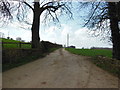
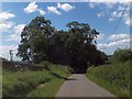
The way to Warren Farm
The Cotswold Way, day four 11:32am
Image: © Ian S
Taken: 20 Apr 2013
0.09 miles
2
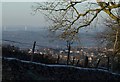
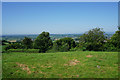
View from Blackquarries Hill
The old Severn Bridge (in Image and Image) can be seen on the left. Nearer at hand is the south-eastern part of Wotton-under-Edge.
Image: © Derek Harper
Taken: 2 Jan 2010
0.09 miles
3
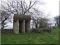
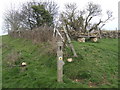
Tank and trailer
Possibly left from the working of a nearby quarry. This scene is along the Cotswold Way about 50 yards from the Warden's seat Image
Image: © Jonathan Billinger
Taken: 30 Mar 2007
0.10 miles
4
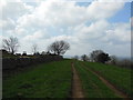
The Cotswold Way at Winterspring Lane
The Cotswold Way, day four 11:46am
Image: © Ian S
Taken: 20 Apr 2013
0.11 miles
5
The Blackwars Herd at Warren Farm
The Cotswold Way, day four 11:32am
Image: © Ian S
Taken: 20 Apr 2013
0.12 miles
6
Hilltop above Warren Farm
The edge of the Cotswold escarpment. Some houses can be seen, but Wotton-under-Edge is mostly hidden by the trees. The Severn estuary is visible in the distance.
Image: © Bill Boaden
Taken: 19 Jul 2016
0.12 miles
7
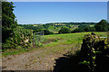
Farmland on Blackquarries Hill
Rolling farmland above Wotton-under-Edge.
Image: © Bill Boaden
Taken: 19 Jul 2016
0.12 miles
8
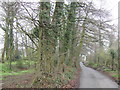
Blackquarries Hill
This lane rises steeply through woods out of Wotton-under-Edge where the south Cotswold plateau has been deeply bisected be river action.
Image: © Jonathan Billinger
Taken: 30 Mar 2007
0.12 miles
9
Wood at the west end of Blackquarries Hill
Image: © David Smith
Taken: 28 Jul 2012
0.12 miles
10
Cotswold Way and the Warden's seat
Placed at a good panoramic viewpoint on the crest of the Cotswold hills above Wotton-under-Edge. The LDF proceeds to the left.
Image: © Jonathan Billinger
Taken: 30 Mar 2007
0.13 miles