IMAGES TAKEN NEAR TO
Bowcott, WOTTON-UNDER-EDGE, GL12 7PT
Introduction
This page details the photographs taken nearby to GL12 7PT by members of the Geograph project.
The Geograph project started in 2005 with the aim of publishing, organising and preserving representative images for every square kilometre of Great Britain, Ireland and the Isle of Man.

There are currently over 7.5m images from over14,400 individuals and you can help contribute to the project by visiting https://www.geograph.org.uk
Image Map
Images are licensed for reuse under creativecommons.org/licenses/by-sa/2.0
Notes
- Clicking on the map will re-center to the selected point.
- The higher the marker number, the further away the image location is from the centre of the postcode.
Image Listing (7 Images Found)
Images are licensed for reuse under creativecommons.org/licenses/by-sa/2.0
Image
Details
Distance
1
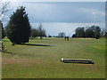
The 1st fairway
A pleasant day at Cotswold Edge golf course
Image: © David Collins
Taken: 29 Mar 2007
0.07 miles
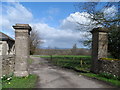
2
Cotswold Edge Golf Club
The entrance to Cotswold Edge Golf Club from the B4058.
Image: © David Dixon
Taken: 29 Feb 2012
0.10 miles
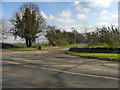
5
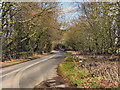
B4058
The B4058, from the entrance to Cotswold Edge Golf Club.
Image: © David Dixon
Taken: 29 Feb 2012
0.12 miles
6
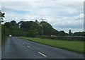
Wide verge beside B4058
Passing the Cotswold Edge Golf Course on the right.
Image: © Ruth Riddle
Taken: 9 Jun 2012
0.15 miles
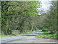
7
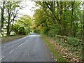
The B4058 passing Cotswold Edge Golf Club
The B4058, the road between Tetbury and Wotton-under-Edge, passing Cotswold Edge Golf Club.
Image: © Philip Halling
Taken: 27 Oct 2016
0.24 miles