IMAGES TAKEN NEAR TO
Southend, WOTTON-UNDER-EDGE, GL12 7PE
Introduction
This page details the photographs taken nearby to GL12 7PE by members of the Geograph project.
The Geograph project started in 2005 with the aim of publishing, organising and preserving representative images for every square kilometre of Great Britain, Ireland and the Isle of Man.

There are currently over 7.5m images from over14,400 individuals and you can help contribute to the project by visiting https://www.geograph.org.uk
Image Map
Images are licensed for reuse under creativecommons.org/licenses/by-sa/2.0
Notes
- Clicking on the map will re-center to the selected point.
- The higher the marker number, the further away the image location is from the centre of the postcode.
Image Listing (5 Images Found)
Images are licensed for reuse under creativecommons.org/licenses/by-sa/2.0
Image
Details
Distance
1

Barn at Southend Farm
Roadside barn at Southend Farm to the south of North Nibley.
Image: © Philip Halling
Taken: 19 Apr 2017
0.05 miles
2
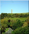
The B4060 south of North Nibley
The Tyndale monument stands on the hill.
Image: © nick macneill
Taken: 14 Oct 2012
0.08 miles
3
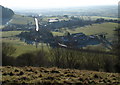
Southend from the Tyndale Monument
From Image, a similar view to Image at almost midday, with the sun directly ahead. Southend consists of three farms; right below is Millmans Farm, with Southend Farm left, and Windmill Fruit Farm with its market garden beyond. The B4060 glistens as it passes through the hamlet.
Image: © Derek Harper
Taken: 2 Jan 2010
0.10 miles
4
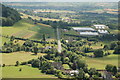
Market Garden
As seen from Tyndall Monument
Image: © John Sparshatt
Taken: 23 Jul 2006
0.11 miles
5
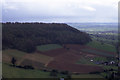
On North Nibley Monument - farmland below Brackenbury Ditches
Image: © Colin Park
Taken: 16 Apr 1990
0.19 miles