IMAGES TAKEN NEAR TO
The Cedars, WOTTON-UNDER-EDGE, GL12 7NU
Introduction
This page details the photographs taken nearby to The Cedars, GL12 7NU by members of the Geograph project.
The Geograph project started in 2005 with the aim of publishing, organising and preserving representative images for every square kilometre of Great Britain, Ireland and the Isle of Man.

There are currently over 7.5m images from over14,400 individuals and you can help contribute to the project by visiting https://www.geograph.org.uk
Image Map
Images are licensed for reuse under creativecommons.org/licenses/by-sa/2.0
Notes
- Clicking on the map will re-center to the selected point.
- The higher the marker number, the further away the image location is from the centre of the postcode.
Image Listing (151 Images Found)
Images are licensed for reuse under creativecommons.org/licenses/by-sa/2.0
Image
Details
Distance
1
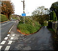
Junction of Coombe Road and The Cedars, Wotton-under-Edge
The Cedars on the right is unsuitable for long vehicles.
Image: © Jaggery
Taken: 28 Oct 2012
0.02 miles
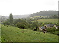
2
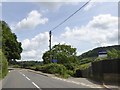
Valley Road, Wotton-Under-Edge
A road which loops away from and then returns to the B4058
Image: © David Smith
Taken: 15 Jun 2018
0.02 miles
3
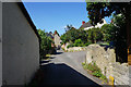
Valley Road, Wotton-under-Edge
An older part on the edge of the town.
Image: © Bill Boaden
Taken: 19 Jul 2016
0.03 miles
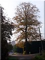
4

The Cotswold Way towards Holywell
The Cotswold Way, day four 11:13am
Image: © Ian S
Taken: 20 Apr 2013
0.04 miles
6
Holywell heifers
A view across Holywell where some cattle munch contentedly. A heavy summer shower adds to the misty effect.
Image: © Neil Owen
Taken: 2 Aug 2014
0.06 miles
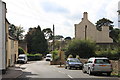
7
Valley Road and St Mary the Virgin
Looking along Valley Road, the church of St Mary the Virgin can just be seen in the distance. The tower dates from the late 14th century.
Image: © Linda Bailey
Taken: 5 Nov 2006
0.06 miles
8
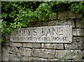
Adey's Lane
Including an unusual reference to a certain house.
Image: © Neil Owen
Taken: 2 Aug 2014
0.06 miles
9

The Cotswold Way towards Holywell
The Cotswold Way, day four 11:13am
Image: © Ian S
Taken: 20 Apr 2013
0.06 miles
10
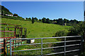
Fields north of Wotton-under-Edge
Below the Cotswold escarpment which curls round the town.
Image: © Bill Boaden
Taken: 19 Jul 2016
0.06 miles