IMAGES TAKEN NEAR TO
Coombe Lane, WOTTON-UNDER-EDGE, GL12 7NQ
Introduction
This page details the photographs taken nearby to Coombe Lane, GL12 7NQ by members of the Geograph project.
The Geograph project started in 2005 with the aim of publishing, organising and preserving representative images for every square kilometre of Great Britain, Ireland and the Isle of Man.

There are currently over 7.5m images from over14,400 individuals and you can help contribute to the project by visiting https://www.geograph.org.uk
Image Map
Images are licensed for reuse under creativecommons.org/licenses/by-sa/2.0
Notes
- Clicking on the map will re-center to the selected point.
- The higher the marker number, the further away the image location is from the centre of the postcode.
Image Listing (23 Images Found)
Images are licensed for reuse under creativecommons.org/licenses/by-sa/2.0
Image
Details
Distance
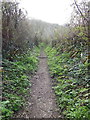
1
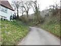
The Cotswold Way at the Haven
The Cotswold Way, day four 11:21am
Image: © Ian S
Taken: 20 Apr 2013
0.01 miles
2
The Cotswold Way towards Blackquarries Hill
The Cotswold Way, day four 11:22am
Image: © Ian S
Taken: 20 Apr 2013
0.02 miles
3
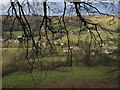
Coombe from the Cotswold Way
One of the hamlets up the valley east of Wotton-Under-Edge, seen through a fringe of beech branches and twigs from the Cotswold Way as it drops steeply down a bridleway from Blackquarries Hill at the point shown in Image In the centre foreground is Frogend farm.
Image: © Derek Harper
Taken: 31 Dec 2009
0.03 miles
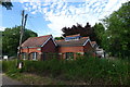
4
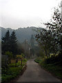
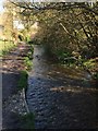
Coombe Lane
Looking along Coombe Lane with Warren Wood in the distance.
Image: © Linda Bailey
Taken: 5 Nov 2006
0.05 miles
5
The Cotswold Way towards Blackquarries Hill
The Cotswold Way, day four 11:22am
Image: © Ian S
Taken: 20 Apr 2013
0.05 miles
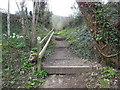
6
The Cotswold Way at Coombe
The Cotswold Way, day four 11:19am
Image: © Ian S
Taken: 20 Apr 2013
0.08 miles
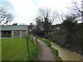
7
Pumping Station, Coombe Lane, Wotton-under-Edge
Image: © Tim Heaton
Taken: 5 Jul 2017
0.08 miles
8
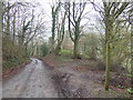
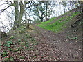
Blackquarries Hill and the Cotswold Way
The steep wooded lane above Wotton-under-Edge at the point where the LDF branches off to the right.
Image: © Jonathan Billinger
Taken: 30 Mar 2007
0.08 miles
10
The Cotswold Way towards Blackquarries Hill
The Cotswold Way, day four 11:25am
Image: © Ian S
Taken: 20 Apr 2013
0.10 miles