IMAGES TAKEN NEAR TO
Coombe, WOTTON-UNDER-EDGE, GL12 7ND
Introduction
This page details the photographs taken nearby to GL12 7ND by members of the Geograph project.
The Geograph project started in 2005 with the aim of publishing, organising and preserving representative images for every square kilometre of Great Britain, Ireland and the Isle of Man.

There are currently over 7.5m images from over14,400 individuals and you can help contribute to the project by visiting https://www.geograph.org.uk
Image Map
Images are licensed for reuse under creativecommons.org/licenses/by-sa/2.0
Notes
- Clicking on the map will re-center to the selected point.
- The higher the marker number, the further away the image location is from the centre of the postcode.
Image Listing (22 Images Found)
Images are licensed for reuse under creativecommons.org/licenses/by-sa/2.0
Image
Details
Distance
1
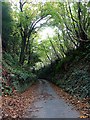
Lane leading to Coombehall Farm
High sided lane leading down to Coombehall Farm and Greenhay Farm.
Image: © Linda Bailey
Taken: 5 Nov 2006
0.08 miles
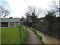
2
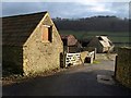
Greenhay Farm
Farm buildings at Coombe, east of Wotton-Under-Edge. They are in sunlight, but the north-facing hillside across the valley in the background (in Image and Image) is in shadow.
Image: © Derek Harper
Taken: 31 Dec 2009
0.13 miles
3
Coombehall Farm
A glimpse of interesting-looking old buildings, though apparently unlisted, from the Cotswold Way as it drops from Blackquarries Hill.
Image: © Derek Harper
Taken: 2 Jan 2010
0.14 miles
4
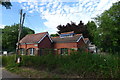
Pumping Station, Coombe Lane, Wotton-under-Edge
Image: © Tim Heaton
Taken: 5 Jul 2017
0.14 miles
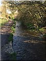
5
The Cotswold Way at Coombe
The Cotswold Way, day four 11:19am
Image: © Ian S
Taken: 20 Apr 2013
0.15 miles
6
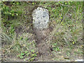
Milestone, Coombe Rd
Set into a steep bank with no verge. Mostly covered in soil & sod. OS Bench Mark at 0.6m AGL. 135.3 m ASL. Limestone, spalling.
Wotton under Edge 1
Milestone Society ID: GL_WENW01
Image: © Mr Red
Taken: 24 Sep 2020
0.16 miles
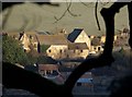
8
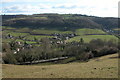
Coombe
The village of Coombe viewed from Coombe Hill
Image: © Philip Halling
Taken: 27 Feb 2005
0.16 miles
9
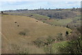
View of Coombe Hill
A view across Coombe Hill, above Wotton-Under-Edge. The hillside has unusual terrace-like lines, these are known as terracettes and are a natural geographical feature.
Image: © Philip Halling
Taken: 27 Feb 2005
0.16 miles
10
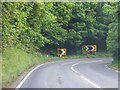
Bend near Coombe Hill
A sharp bend in the B4058.
Image: © Ruth Riddle
Taken: 9 Jun 2012
0.17 miles